Onzo geodata
Onzo (Liguria) is a seat of a third-order administrative division; located in Italy in Europe/Rome (GMT+2) time zone. With population of 223 people, there are 11013 cities with bigger population in this country. Compared to other cities in Italy, 54% of cities are located further ↑North; 92.9% of cities are located further →East and 73.6% of cities have lower elevation than Onzo. Note1


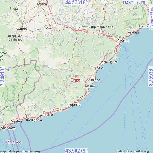
Onzo GPS coordinates[2]
44° 4' 12.468" North, 8° 3' 8.1" East
| Map corner | latitude | longitude |
|---|---|---|
| Upper-left | 44.57316°, | 7.34913° |
| Center: | 44.07013°, | 8.05225° |
| Lower-right: | 43.56279°, | 8.75538° |
| Map W x H: | 112.3×112.3 km | = 69.8×69.8mi |
| max Lat: | 47.04031° ⇑54% North |
| Onzo: | 44.07013° |
| min Lat: | ⇓46% South 35.50142° |
| min Long | Onzo | max Long |
| 6.69888° | 8.05225° | 18.48682° |
| W 7.1%⇐ | ⇒92.9% E |
Elevation
Elevation of Onzo is 433 m = 1421 ft, and this is 126.3 m = 414 ft above average elevation for this country.
| Max E: |
2085 m = 6841 ft | 26.4% |
| Onzo | 433 m 1421 ft | |
| Avg. | 306.7 m = 1006 ft | |
Min E: |
-4 m = -13 ft | 73.6% |
See also: Italy elevation on elevation.city.
Geographical zone
Onzo is located in North temperate zone (between Tropic of Cancer and the Arctic Circle). Distance of this Northern Tropic circle is 2294.2 km =1425.5 mi to South.| Distance of | km | miles | from Onzo |
|---|---|---|---|
| North Pole | 5106.9 | 3173.3 | to North |
| Arctic Circle | 2501 | 1554 | to North |
| Tropic Cancer | 2294.2 | 1425.5 | to South |
| Equator | 4900.1 | 3044.8 | to South |


Nearby cities:
15 places around Onzo: (largest is in red/bold)
• Alto
5.9 km =3.7 mi,  316°
316°
• Aquila di Arroscia
4.1 km =2.5 mi,  295°
295°
• Arnasco
4.5 km =2.8 mi,  78°
78°
• Borghetto d'Arroscia
5.9 km =3.7 mi,  255°
255°
• Borgo di Ranzo
3.2 km =2 mi,  248°
248°
• Casanova Lerrone
4.2 km =2.6 mi,  185°
185°
• Castelbianco
5.2 km =3.2 mi,  20°
20°
• Chiesa
4.6 km =2.9 mi, 79°
• Garlenda
5.4 km =3.4 mi,  139°
139°
• Nasino-Borgo
5.1 km =3.2 mi,  341°
341°
• Ortovero
4.2 km =2.6 mi,  115°
115°
• Testico
7.5 km =4.7 mi,  196°
196°
• Vendone
1.7 km =1.1 mi,  63°
63°
• Villafranca
5.9 km =3.7 mi,  134°
134°
• Zuccarello
6.9 km =4.3 mi,  50°
50°
Sources, notices
• [Note1] Compared only with cities in Italy existing in our database
• [Src1] Map data: © OpenStreetMap contributors (CC-BY-SA)
• [Src2] Other city data from geonames.org with taken over terms of usage.
• [Src3] Geographical zone / Annual Mean Temperature by Robert A. Rohde @ Wikipedia
