Testico geodata
Testico (Liguria) is a seat of a third-order administrative division; located in Italy in Europe/Rome (GMT+2) time zone. With population of 102 people, there are 11432 cities with bigger population in this country. Compared to other cities in Italy, 54.6% of cities are located further ↑North; 93.3% of cities are located further →East and 78.2% of cities have lower elevation than Testico. Note1


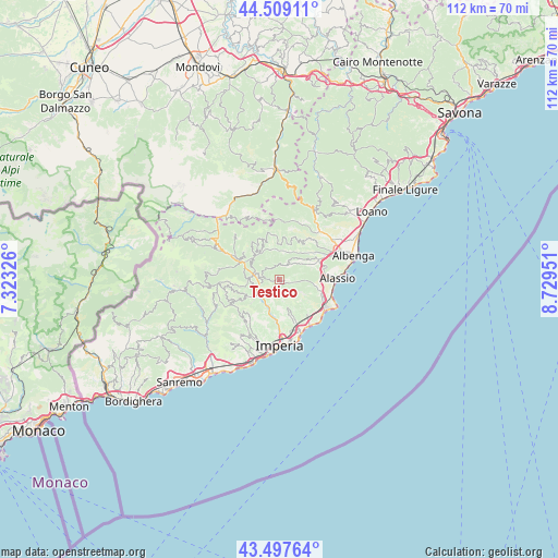
Testico GPS coordinates[2]
44° 0' 19.908" North, 8° 1' 35.004" East
| Map corner | latitude | longitude |
|---|---|---|
| Upper-left | 44.50911°, | 7.32326° |
| Center: | 44.00553°, | 8.02639° |
| Lower-right: | 43.49764°, | 8.72951° |
| Map W x H: | 112.5×112.5 km | = 69.9×69.9mi |
| max Lat: | 47.04031° ⇑54.6% North |
| Testico: | 44.00553° |
| min Lat: | ⇓45.4% South 35.50142° |
| min Long | Testico | max Long |
| 6.69888° | 8.02639° | 18.48682° |
| W 6.7%⇐ | ⇒93.3% E |
Elevation
Elevation of Testico is 495 m = 1624 ft, and this is 188.3 m = 618 ft above average elevation for this country.
| Max E: |
2085 m = 6841 ft | 21.8% |
| Testico | 495 m 1624 ft | |
| Avg. | 306.7 m = 1006 ft | |
Min E: |
-4 m = -13 ft | 78.2% |
See also: Italy elevation on elevation.city.
Geographical zone
Testico is located in North temperate zone (between Tropic of Cancer and the Arctic Circle). Distance of this Northern Tropic circle is 2287 km =1421.1 mi to South.| Distance of | km | miles | from Testico |
|---|---|---|---|
| North Pole | 5114.1 | 3177.8 | to North |
| Arctic Circle | 2508.2 | 1558.5 | to North |
| Tropic Cancer | 2287 | 1421.1 | to South |
| Equator | 4893 | 3040.4 | to South |


Nearby cities:
15 places around Testico: (largest is in red/bold)
• Borghetto d'Arroscia
6.8 km =4.2 mi,  327°
327°
• Borgo di Ranzo
6.1 km =3.8 mi,  351°
351°
• Caravonica
5.6 km =3.5 mi,  255°
255°
• Casanova Lerrone
3.4 km =2.1 mi,  29°
29°
• Cesio
4.1 km =2.5 mi,  273°
273°
• Chiusanico
4.5 km =2.8 mi,  217°
217°
• Chiusavecchia
5.4 km =3.4 mi, 218°
• Diano Arentino
6.3 km =3.9 mi,  168°
168°
• Garlenda
6.3 km =3.9 mi,  60°
60°
• Lucinasco
6.9 km =4.3 mi,  230°
230°
• Rossi
2.7 km =1.7 mi,  102°
102°
• Stellanello
2.8 km =1.7 mi, 102°
• Vessalico
6.9 km =4.3 mi,  310°
310°
• Villa Faraldi
6.5 km =4 mi,  129°
129°
• Villafranca
7 km =4.3 mi, 64°
Sources, notices
• [Note1] Compared only with cities in Italy existing in our database
• [Src1] Map data: © OpenStreetMap contributors (CC-BY-SA)
• [Src2] Other city data from geonames.org with taken over terms of usage.
• [Src3] Geographical zone / Annual Mean Temperature by Robert A. Rohde @ Wikipedia
