Gargnano geodata
Gargnano (Lombardy) is a seat of a third-order administrative division; located in Italy in Europe/Rome (GMT+2) time zone. With population of 2,221 people, there are 3843 cities with bigger population in this country. Compared to other cities in Italy, 80.5% of cities are located further ↓South; 61.3% of cities are located further →East and 68.3% of cities have higher elevation than Gargnano. Note1


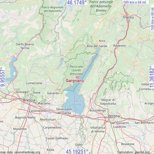
Gargnano GPS coordinates[2]
45° 41' 9.096" North, 10° 39' 31.284" East
| Map corner | latitude | longitude |
|---|---|---|
| Upper-left | 46.1749°, | 9.95557° |
| Center: | 45.68586°, | 10.65869° |
| Lower-right: | 45.19251°, | 11.36182° |
| Map W x H: | 109.2×109.2 km | = 67.9×67.9mi |
| max Lat: | 47.04031° ⇑19.5% North |
| Gargnano: | 45.68586° |
| min Lat: | ⇓80.5% South 35.50142° |
| min Long | Gargnano | max Long |
| 6.69888° | 10.65869° | 18.48682° |
| W 38.7%⇐ | ⇒61.3% E |
Elevation
Elevation of Gargnano is 107 m = 351 ft, and this is 199.7 m = 655 ft below average elevation for this country.
| Max E: |
2085 m = 6841 ft | 68.3% |
| Avg. | 306.7 m = 1006 ft | |
| Gargnano | 107 m = 351 ft | |
Min E: |
-4 m = -13 ft | 31.7% |
See also: Italy elevation on elevation.city.
Geographical zone
Gargnano is located in North temperate zone (between Tropic of Cancer and the Arctic Circle). Distance of this North polar circle is 2321.4 km =1442.5 mi to North.| Distance of | km | miles | from Gargnano |
|---|---|---|---|
| North Pole | 4927.3 | 3061.7 | to North |
| Arctic Circle | 2321.4 | 1442.5 | to North |
| Tropic Cancer | 2473.9 | 1537.2 | to South |
| Equator | 5079.8 | 3156.4 | to South |


Nearby cities:
15 places around Gargnano: (largest is in red/bold)
• Brenzone
8.1 km =5 mi,  78°
78°
• Capovalle
11.6 km =7.2 mi,  310°
310°
• Costermano
12.7 km =7.9 mi,  150°
150°
• Gardola
7.8 km =4.8 mi,  36°
36°
• Gardone Riviera
9.9 km =6.2 mi,  226°
226°
• Magasa
11.1 km =6.9 mi,  342°
342°
• Magugnano
8.2 km =5.1 mi, 78°
• Pesina Spezie
12.7 km =7.9 mi,  136°
136°
• Pesine Bisse
12.1 km =7.5 mi, 142°
• Pieve
12.4 km =7.7 mi, 38°
• San Zeno
8 km =5 mi, 136°
• San Zeno di Montagna
7.8 km =4.8 mi,  133°
133°
• Torri del Benaco
8.7 km =5.4 mi,  165°
165°
• Toscolano Maderno
6.5 km =4 mi,  217°
217°
• Valvestino
9.7 km =6 mi,  329°
329°
Sources, notices
• [Note1] Compared only with cities in Italy existing in our database
• [Src1] Map data: © OpenStreetMap contributors (CC-BY-SA)
• [Src2] Other city data from geonames.org with taken over terms of usage.
• [Src3] Geographical zone / Annual Mean Temperature by Robert A. Rohde @ Wikipedia
