Gardola geodata
Gardola (Lombardy) is a seat of a third-order administrative division; located in Italy in Europe/Rome (GMT+2) time zone. With population of 623 people, there are 8818 cities with bigger population in this country. Compared to other cities in Italy, 83.2% of cities are located further ↓South; 60.8% of cities are located further →East and 84.9% of cities have lower elevation than Gardola. Note1


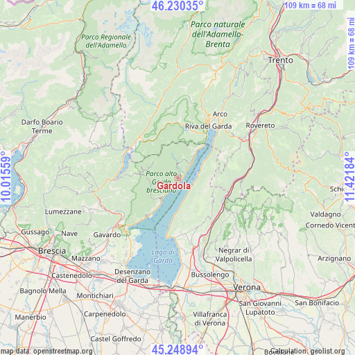
Gardola GPS coordinates[2]
45° 44' 30.48" North, 10° 43' 7.356" East
| Map corner | latitude | longitude |
|---|---|---|
| Upper-left | 46.23035°, | 10.01559° |
| Center: | 45.7418°, | 10.71871° |
| Lower-right: | 45.24894°, | 11.42184° |
| Map W x H: | 109.1×109.1 km | = 67.8×67.8mi |
| max Lat: | 47.04031° ⇑16.8% North |
| Gardola: | 45.7418° |
| min Lat: | ⇓83.2% South 35.50142° |
| min Long | Gardola | max Long |
| 6.69888° | 10.71871° | 18.48682° |
| W 39.2%⇐ | ⇒60.8% E |
Elevation
Elevation of Gardola is 608 m = 1995 ft, and this is 301.3 m = 989 ft above average elevation for this country.
| Max E: |
2085 m = 6841 ft | 15.1% |
| Gardola | 608 m 1995 ft | |
| Avg. | 306.7 m = 1006 ft | |
Min E: |
-4 m = -13 ft | 84.9% |
See also: Italy elevation on elevation.city.
Geographical zone
Gardola is located in North temperate zone (between Tropic of Cancer and the Arctic Circle). Distance of this North polar circle is 2315.2 km =1438.6 mi to North.| Distance of | km | miles | from Gardola |
|---|---|---|---|
| North Pole | 4921.1 | 3057.8 | to North |
| Arctic Circle | 2315.2 | 1438.6 | to North |
| Tropic Cancer | 2480.1 | 1541.1 | to South |
| Equator | 5086 | 3160.3 | to South |


Nearby cities:
15 places around Gardola: (largest is in red/bold)
• Bondone
14.9 km =9.3 mi,  298°
298°
• Brenzone
5.7 km =3.5 mi,  145°
145°
• Capovalle
13.6 km =8.5 mi,  275°
275°
• Ferrara di Monte Baldo
13.2 km =8.2 mi,  124°
124°
• Gargnano
7.8 km =4.8 mi,  216°
216°
• Limone sul Garda
9.9 km =6.2 mi,  35°
35°
• Magasa
9.1 km =5.7 mi, 298°
• Magugnano
5.7 km =3.5 mi,  143°
143°
• Malcesine
7.3 km =4.5 mi,  72°
72°
• Pieve
4.7 km =2.9 mi, 42°
• San Zeno
12 km =7.5 mi,  175°
175°
• San Zeno di Montagna
11.6 km =7.2 mi,  174°
174°
• Torri del Benaco
14.9 km =9.3 mi,  189°
189°
• Toscolano Maderno
14.3 km =8.9 mi, 217°
• Valvestino
9.8 km =6.1 mi, 282°
Sources, notices
• [Note1] Compared only with cities in Italy existing in our database
• [Src1] Map data: © OpenStreetMap contributors (CC-BY-SA)
• [Src2] Other city data from geonames.org with taken over terms of usage.
• [Src3] Geographical zone / Annual Mean Temperature by Robert A. Rohde @ Wikipedia
