Fosdinovo geodata
Fosdinovo (Tuscany) is a seat of a third-order administrative division; located in Italy in Europe/Rome (GMT+2) time zone. With population of 403 people, there are 10267 cities with bigger population in this country. Compared to other cities in Italy, 53.4% of cities are located further ↑North; 67.6% of cities are located further →East and 77.7% of cities have lower elevation than Fosdinovo. Note1


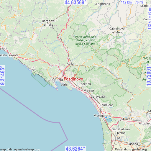
Fosdinovo GPS coordinates[2]
44° 7' 59.52" North, 10° 1' 4.008" East
| Map corner | latitude | longitude |
|---|---|---|
| Upper-left | 44.63569°, | 9.31465° |
| Center: | 44.1332°, | 10.01778° |
| Lower-right: | 43.6264°, | 10.72091° |
| Map W x H: | 112.2×112.2 km | = 69.7×69.7mi |
| max Lat: | 47.04031° ⇑53.4% North |
| Fosdinovo: | 44.1332° |
| min Lat: | ⇓46.6% South 35.50142° |
| min Long | Fosdinovo | max Long |
| 6.69888° | 10.01778° | 18.48682° |
| W 32.4%⇐ | ⇒67.6% E |
Elevation
Elevation of Fosdinovo is 488 m = 1601 ft, and this is 181.3 m = 595 ft above average elevation for this country.
| Max E: |
2085 m = 6841 ft | 22.3% |
| Fosdinovo | 488 m 1601 ft | |
| Avg. | 306.7 m = 1006 ft | |
Min E: |
-4 m = -13 ft | 77.7% |
See also: Italy elevation on elevation.city.
Geographical zone
Fosdinovo is located in North temperate zone (between Tropic of Cancer and the Arctic Circle). Distance of this Northern Tropic circle is 2301.2 km =1429.9 mi to South.| Distance of | km | miles | from Fosdinovo |
|---|---|---|---|
| North Pole | 5099.9 | 3168.9 | to North |
| Arctic Circle | 2494 | 1549.7 | to North |
| Tropic Cancer | 2301.2 | 1429.9 | to South |
| Equator | 4907.2 | 3049.2 | to South |


Nearby cities:
15 places around Fosdinovo: (largest is in red/bold)
• Ameglia
8.1 km =5 mi,  210°
210°
• Arcola
8.6 km =5.3 mi,  258°
258°
• Aulla
8.7 km =5.4 mi,  338°
338°
• Borghetto-Melara
4.4 km =2.7 mi, 209°
• Carrara
8.8 km =5.5 mi,  133°
133°
• Casano-Dogana-Isola
6.5 km =4 mi,  168°
168°
• Castelnuovo Magra
3.7 km =2.3 mi,  180°
180°
• Colombiera-Molicciara
5.1 km =3.2 mi,  186°
186°
• Gragnana
6.6 km =4.1 mi,  124°
124°
• Luni Mare
8.3 km =5.2 mi, 188°
• Pallerone
8.1 km =5 mi,  351°
351°
• Romito Magra
7.9 km =4.9 mi,  240°
240°
• Santo Stefano di Magra
7.9 km =4.9 mi,  282°
282°
• Sarzana
5 km =3.1 mi, 241°
• Torano
8.3 km =5.2 mi, 123°
Sources, notices
• [Note1] Compared only with cities in Italy existing in our database
• [Src1] Map data: © OpenStreetMap contributors (CC-BY-SA)
• [Src2] Other city data from geonames.org with taken over terms of usage.
• [Src3] Geographical zone / Annual Mean Temperature by Robert A. Rohde @ Wikipedia
