Romito Magra geodata
Romito Magra (Liguria) is a populated place; located in Italy in Europe/Rome (GMT+2) time zone. With population of 2,558 people, there are 3456 cities with bigger population in this country. Compared to other cities in Italy, 53.7% of cities are located further ↑North; 68.5% of cities are located further →East and 94.1% of cities have higher elevation than Romito Magra. Note1


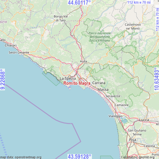
Romito Magra GPS coordinates[2]
44° 5' 54.168" North, 9° 55' 54.48" East
| Map corner | latitude | longitude |
|---|---|---|
| Upper-left | 44.60117°, | 9.22868° |
| Center: | 44.09838°, | 9.9318° |
| Lower-right: | 43.59128°, | 10.63493° |
| Map W x H: | 112.3×112.3 km | = 69.8×69.8mi |
| max Lat: | 47.04031° ⇑53.7% North |
| Romito Magra: | 44.09838° |
| min Lat: | ⇓46.3% South 35.50142° |
| min Long | Romito Magra | max Long |
| 6.69888° | 9.9318° | 18.48682° |
| W 31.5%⇐ | ⇒68.5% E |
Elevation
Elevation of Romito Magra is 10 m = 33 ft, and this is 296.7 m = 973 ft below average elevation for this country.
| Max E: |
2085 m = 6841 ft | 94.1% |
| Avg. | 306.7 m = 1006 ft | |
| Romito Magra | 10 m = 33 ft | |
Min E: |
-4 m = -13 ft | 5.9% |
See also: Italy elevation on elevation.city.
Geographical zone
Romito Magra is located in North temperate zone (between Tropic of Cancer and the Arctic Circle). Distance of this Northern Tropic circle is 2297.4 km =1427.5 mi to South.| Distance of | km | miles | from Romito Magra |
|---|---|---|---|
| North Pole | 5103.8 | 3171.4 | to North |
| Arctic Circle | 2497.9 | 1552.1 | to North |
| Tropic Cancer | 2297.4 | 1427.5 | to South |
| Equator | 4903.3 | 3046.8 | to South |


Nearby cities:
15 places around Romito Magra: (largest is in red/bold)
• Ameglia
4.1 km =2.5 mi,  138°
138°
• Arcola
2.7 km =1.7 mi,  323°
323°
• Borghetto-Melara
4.7 km =2.9 mi,  89°
89°
• Castelnuovo Magra
6.8 km =4.2 mi, 88°
• Colombiera-Molicciara
6.4 km =4 mi,  100°
100°
• Fiumaretta di Ameglia
6.8 km =4.2 mi, 137°
• Lerici
3 km =1.9 mi,  213°
213°
• Luni Mare
7.2 km =4.5 mi,  127°
127°
• Pitelli
3.8 km =2.4 mi,  263°
263°
• San Terenzo
3.2 km =2 mi,  242°
242°
• Santo Stefano di Magra
5.7 km =3.5 mi,  351°
351°
• Sarzana
2.8 km =1.7 mi,  58°
58°
• Stazione-Fornola
4.7 km =2.9 mi, 317°
• Tellaro
4.1 km =2.5 mi,  184°
184°
• Vezzano Ligure
6 km =3.7 mi, 323°
Sources, notices
• [Note1] Compared only with cities in Italy existing in our database
• [Src1] Map data: © OpenStreetMap contributors (CC-BY-SA)
• [Src2] Other city data from geonames.org with taken over terms of usage.
• [Src3] Geographical zone / Annual Mean Temperature by Robert A. Rohde @ Wikipedia
