Forlimpopoli geodata
Forlimpopoli (Emilia-Romagna) is a seat of a third-order administrative division; located in Italy in Europe/Rome (GMT+2) time zone. With population of 9,392 people, there are 1001 cities with bigger population in this country. Compared to other cities in Italy, 52.8% of cities are located further ↑North; 57.7% of cities are located further ←West and 86.1% of cities have higher elevation than Forlimpopoli. Note1
Administrative division(s):
- Level 1: Emilia-Romagna
- Level 2: Provincia di Forlì-Cesena
- Level 3: Forlimpopoli


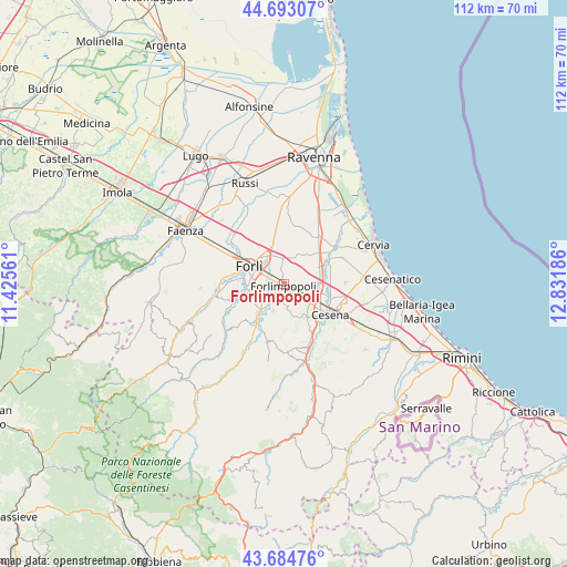
Forlimpopoli GPS coordinates[2]
44° 11' 27.852" North, 12° 7' 43.428" East
| Map corner | latitude | longitude |
|---|---|---|
| Upper-left | 44.69307°, | 11.42561° |
| Center: | 44.19107°, | 12.12873° |
| Lower-right: | 43.68476°, | 12.83186° |
| Map W x H: | 112.1×112.1 km | = 69.7×69.7mi |
| max Lat: | 47.04031° ⇑52.8% North |
| Forlimpopoli: | 44.19107° |
| min Lat: | ⇓47.2% South 35.50142° |
| min Long | Forlimpopoli | max Long |
| 6.69888° | 12.12873° | 18.48682° |
| W 57.7%⇐ | ⇒42.3% E |
Elevation
Elevation of Forlimpopoli is 28 m = 92 ft, and this is 278.7 m = 914 ft below average elevation for this country.
| Max E: |
2085 m = 6841 ft | 86.1% |
| Avg. | 306.7 m = 1006 ft | |
| Forlimpopoli | 28 m = 92 ft | |
Min E: |
-4 m = -13 ft | 13.9% |
See also: Italy elevation on elevation.city.
Geographical zone
Forlimpopoli is located in North temperate zone (between Tropic of Cancer and the Arctic Circle). Distance of this Northern Tropic circle is 2307.7 km =1433.9 mi to South.| Distance of | km | miles | from Forlimpopoli |
|---|---|---|---|
| North Pole | 5093.5 | 3165 | to North |
| Arctic Circle | 2487.6 | 1545.7 | to North |
| Tropic Cancer | 2307.7 | 1433.9 | to South |
| Equator | 4913.6 | 3053.2 | to South |


Nearby cities:
15 places around Forlimpopoli: (largest is in red/bold)
• Bertinoro
4.7 km =2.9 mi,  172°
172°
• Cannuzzo
10.2 km =6.3 mi,  61°
61°
• Capocolle
4.8 km =3 mi,  127°
127°
• Carpena
5.2 km =3.2 mi,  262°
262°
• Carpinello
5.4 km =3.4 mi,  351°
351°
• Cesena
10.8 km =6.7 mi,  122°
122°
• Forlì
7.7 km =4.8 mi,  296°
296°
• Fratta Terme
5.9 km =3.7 mi,  201°
201°
• Meldola
8.8 km =5.5 mi,  216°
216°
• Panighina
3.5 km =2.2 mi, 128°
• Roncadello
10.7 km =6.6 mi,  321°
321°
• San Lorenzo in Noceto
10.3 km =6.4 mi,  251°
251°
• San Zaccaria
11.1 km =6.9 mi,  37°
37°
• Santa Maria Nuova
5.3 km =3.3 mi,  79°
79°
• Selbagnone
2.5 km =1.6 mi, 219°
Sources, notices
• [Note1] Compared only with cities in Italy existing in our database
• [Src1] Map data: © OpenStreetMap contributors (CC-BY-SA)
• [Src2] Other city data from geonames.org with taken over terms of usage.
• [Src3] Geographical zone / Annual Mean Temperature by Robert A. Rohde @ Wikipedia
