San Lorenzo in Noceto geodata
San Lorenzo in Noceto (Emilia-Romagna) is a populated place; located in Italy in Europe/Rome (GMT+2) time zone. With population of 893 people, there are 7196 cities with bigger population in this country. Compared to other cities in Italy, 53.2% of cities are located further ↑North; 55.9% of cities are located further ←West and 77.9% of cities have higher elevation than San Lorenzo in Noceto. Note1
Administrative division(s):
- Level 1: Emilia-Romagna
- Level 2: Provincia di Forlì-Cesena
- Level 3: Forlì
Current local time in San Lorenzo in Noceto:
11:20 PM, WednesdayDifference from your time zone: hours


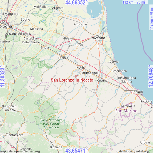
San Lorenzo in Noceto GPS coordinates[2]
44° 9' 40.572" North, 12° 0' 22.86" East
| Map corner | latitude | longitude |
|---|---|---|
| Upper-left | 44.66352°, | 11.30323° |
| Center: | 44.16127°, | 12.00635° |
| Lower-right: | 43.65471°, | 12.70948° |
| Map W x H: | 112.2×112.2 km | = 69.7×69.7mi |
| max Lat: | 47.04031° ⇑53.2% North |
| San Lorenzo in Noceto: | 44.16127° |
| min Lat: | ⇓46.8% South 35.50142° |
| min Long | San Lorenzo in | max Long |
| 6.69888° | 12.00635° | 18.48682° |
| W 55.9%⇐ | ⇒44.1% E |
Elevation
Elevation of San Lorenzo in Noceto is 60 m = 197 ft, and this is 246.7 m = 809 ft below average elevation for this country.
| Max E: |
2085 m = 6841 ft | 77.9% |
| Avg. | 306.7 m = 1006 ft | |
| San Lorenzo in Noceto | 60 m = 197 ft | |
Min E: |
-4 m = -13 ft | 22.1% |
See also: Italy elevation on elevation.city.
Geographical zone
San Lorenzo in Noceto is located in North temperate zone (between Tropic of Cancer and the Arctic Circle). Distance of this Northern Tropic circle is 2304.4 km =1431.9 mi to South.| Distance of | km | miles | from San Lorenzo in Noceto |
|---|---|---|---|
| North Pole | 5096.8 | 3167 | to North |
| Arctic Circle | 2490.9 | 1547.8 | to North |
| Tropic Cancer | 2304.4 | 1431.9 | to South |
| Equator | 4910.3 | 3051.1 | to South |


Nearby cities:
15 places around San Lorenzo in Noceto: (largest is in red/bold)
• Bertinoro
10.5 km =6.5 mi,  97°
97°
• Carpena
5.3 km =3.3 mi,  59°
59°
• Castrocaro Terme
4.8 km =3 mi,  289°
289°
• Castrocaro Terme e Terra del Sole
4.6 km =2.9 mi,  307°
307°
• Dovadola
10.5 km =6.5 mi,  245°
245°
• Fiumana
2.5 km =1.6 mi,  217°
217°
• Forlimpopoli
10.3 km =6.4 mi,  71°
71°
• Forlì
7.3 km =4.5 mi,  22°
22°
• Fratta Terme
7.9 km =4.9 mi,  105°
105°
• Meldola
5.8 km =3.6 mi,  129°
129°
• Predappio
6.7 km =4.2 mi,  195°
195°
• Roncadello
12.2 km =7.6 mi,  14°
14°
• San Colombano
7.8 km =4.8 mi,  153°
153°
• Selbagnone
8.3 km =5.2 mi,  80°
80°
• Villanova
9.8 km =6.1 mi,  347°
347°
Sources, notices
• [Note1] Compared only with cities in Italy existing in our database
• [Src1] Map data: © OpenStreetMap contributors (CC-BY-SA)
• [Src2] Other city data from geonames.org with taken over terms of usage.
• [Src3] Geographical zone / Annual Mean Temperature by Robert A. Rohde @ Wikipedia
