Cesena geodata
Cesena (Emilia-Romagna) is a seat of a third-order administrative division; located in Italy in Europe/Rome (GMT+2) time zone. With population of 79,398 people, there are 55 cities with bigger population in this country. Compared to other cities in Italy, 53.4% of cities are located further ↑North; 59.3% of cities are located further ←West and 81.2% of cities have higher elevation than Cesena. Note1
Administrative division(s):
- Level 1: Emilia-Romagna
- Level 2: Provincia di Forlì-Cesena
- Level 3: Cesena


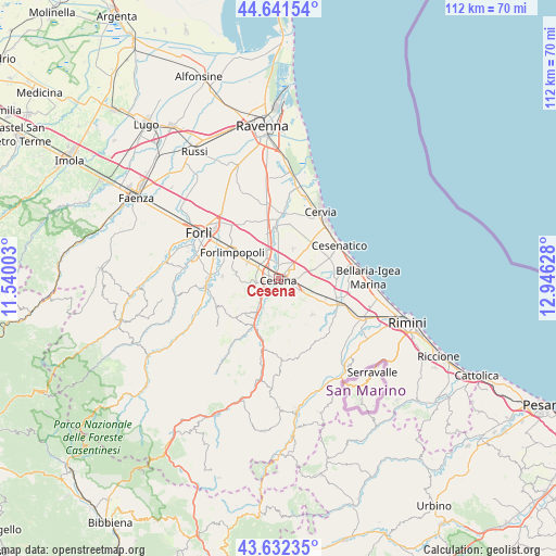
Cesena GPS coordinates[2]
44° 8' 20.76" North, 12° 14' 35.34" East
| Map corner | latitude | longitude |
|---|---|---|
| Upper-left | 44.64154°, | 11.54003° |
| Center: | 44.1391°, | 12.24315° |
| Lower-right: | 43.63235°, | 12.94628° |
| Map W x H: | 112.2×112.2 km | = 69.7×69.7mi |
| max Lat: | 47.04031° ⇑53.4% North |
| Cesena: | 44.1391° |
| min Lat: | ⇓46.6% South 35.50142° |
| min Long | Cesena | max Long |
| 6.69888° | 12.24315° | 18.48682° |
| W 59.3%⇐ | ⇒40.7% E |
Elevation
Elevation of Cesena is 45 m = 148 ft, and this is 261.7 m = 859 ft below average elevation for this country.
| Max E: |
2085 m = 6841 ft | 81.2% |
| Avg. | 306.7 m = 1006 ft | |
| Cesena | 45 m = 148 ft | |
Min E: |
-4 m = -13 ft | 18.8% |
See also: Cesena elevation on elevation.city.
Geographical zone
Cesena is located in North temperate zone (between Tropic of Cancer and the Arctic Circle). Distance of this Northern Tropic circle is 2301.9 km =1430.3 mi to South.| Distance of | km | miles | from Cesena |
|---|---|---|---|
| North Pole | 5099.3 | 3168.6 | to North |
| Arctic Circle | 2493.4 | 1549.3 | to North |
| Tropic Cancer | 2301.9 | 1430.3 | to South |
| Equator | 4907.8 | 3049.6 | to South |


Nearby cities:
15 places around Cesena: (largest is in red/bold)
• Bagnarola
8.4 km =5.2 mi,  72°
72°
• Bertinoro
8.6 km =5.3 mi,  277°
277°
• Borello
10.3 km =6.4 mi,  209°
209°
• Budrio
8.9 km =5.5 mi,  119°
119°
• Cannuzzo
10.7 km =6.6 mi,  359°
359°
• Capocolle
6 km =3.7 mi,  298°
298°
• Forlimpopoli
10.8 km =6.7 mi, 302°
• Fratta Terme
11.3 km =7 mi,  271°
271°
• Gambettola
7.9 km =4.9 mi,  107°
107°
• Longiano
10 km =6.2 mi,  136°
136°
• Montiano
8 km =5 mi, 142°
• Panighina
7.3 km =4.5 mi, 299°
• Pisignano
11.2 km =7 mi,  10°
10°
• Sala
11.4 km =7.1 mi,  80°
80°
• Santa Maria Nuova
7.8 km =4.8 mi,  329°
329°
Sources, notices
• [Note1] Compared only with cities in Italy existing in our database
• [Src1] Map data: © OpenStreetMap contributors (CC-BY-SA)
• [Src2] Other city data from geonames.org with taken over terms of usage.
• [Src3] Geographical zone / Annual Mean Temperature by Robert A. Rohde @ Wikipedia
