Fondo geodata
Fondo (Trentino-Alto Adige) is a seat of a third-order administrative division; located in Italy in Europe/Rome (GMT+2) time zone. With population of 1,135 people, there are 6163 cities with bigger population in this country. Compared to other cities in Italy, 98% of cities are located further ↓South; 55.3% of cities are located further →East and 96.7% of cities have lower elevation than Fondo. Note1
Administrative division(s):
- Level 1: Trentino-Alto Adige
- Level 2: Provincia autonoma di Trento
- Level 3: Fondo


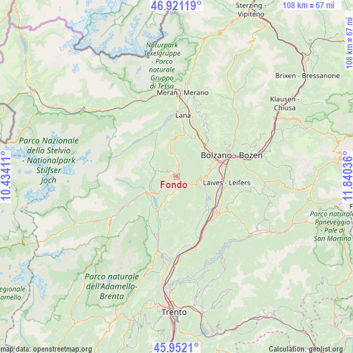
Fondo GPS coordinates[2]
46° 26' 19.68" North, 11° 8' 14.028" East
| Map corner | latitude | longitude |
|---|---|---|
| Upper-left | 46.92119°, | 10.43411° |
| Center: | 46.4388°, | 11.13723° |
| Lower-right: | 45.9521°, | 11.84036° |
| Map W x H: | 107.8×107.8 km | = 67×67mi |
| max Lat: | 47.04031° ⇑2% North |
| Fondo: | 46.4388° |
| min Lat: | ⇓98% South 35.50142° |
| min Long | Fondo | max Long |
| 6.69888° | 11.13723° | 18.48682° |
| W 44.7%⇐ | ⇒55.3% E |
Elevation
Elevation of Fondo is 978 m = 3209 ft, and this is 671.3 m = 2202 ft above average elevation for this country.
| Max E: |
2085 m = 6841 ft | 3.3% |
| Fondo | 978 m 3209 ft | |
| Avg. | 306.7 m = 1006 ft | |
Min E: |
-4 m = -13 ft | 96.7% |
See also: Italy elevation on elevation.city.
Geographical zone
Fondo is located in North temperate zone (between Tropic of Cancer and the Arctic Circle). Distance of this North polar circle is 2237.7 km =1390.4 mi to North.| Distance of | km | miles | from Fondo |
|---|---|---|---|
| North Pole | 4843.6 | 3009.7 | to North |
| Arctic Circle | 2237.7 | 1390.4 | to North |
| Tropic Cancer | 2557.6 | 1589.2 | to South |
| Equator | 5163.5 | 3208.4 | to South |


Nearby cities:
15 places around Fondo: (largest is in red/bold)
• Amblar
4.9 km =3 mi,  171°
171°
• Brez
2.5 km =1.6 mi,  253°
253°
• Castelfondo
2.4 km =1.5 mi,  322°
322°
• Cavareno
3.5 km =2.2 mi,  177°
177°
• Cloz
4.7 km =2.9 mi,  237°
237°
• Dambel
5.1 km =3.2 mi,  221°
221°
• Don
5.5 km =3.4 mi, 180°
• Lauregno
6 km =3.7 mi,  286°
286°
• Malosco
0.8 km =0.5 mi,  113°
113°
• Romallo
7.1 km =4.4 mi,  229°
229°
• Romeno
5.1 km =3.2 mi,  195°
195°
• Ronzone
2 km =1.2 mi,  143°
143°
• Ruffrè
4.1 km =2.5 mi,  130°
130°
• San Felice
6.2 km =3.9 mi,  355°
355°
• Sarnonico
2.2 km =1.4 mi, 170°
Sources, notices
• [Note1] Compared only with cities in Italy existing in our database
• [Src1] Map data: © OpenStreetMap contributors (CC-BY-SA)
• [Src2] Other city data from geonames.org with taken over terms of usage.
• [Src3] Geographical zone / Annual Mean Temperature by Robert A. Rohde @ Wikipedia
