Ferrandina geodata
Ferrandina (Basilicate) is a seat of a third-order administrative division; located in Italy in Europe/Rome (GMT+2) time zone. With population of 8,718 people, there are 1094 cities with bigger population in this country. Compared to other cities in Italy, 84.1% of cities are located further ↑North; 96.1% of cities are located further ←West and 76% of cities have lower elevation than Ferrandina. Note1


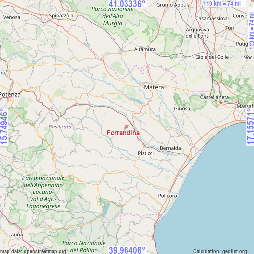
Ferrandina GPS coordinates[2]
40° 30' 3.024" North, 16° 27' 9.288" East
| Map corner | latitude | longitude |
|---|---|---|
| Upper-left | 41.03336°, | 15.74946° |
| Center: | 40.50084°, | 16.45258° |
| Lower-right: | 39.96406°, | 17.15571° |
| Map W x H: | 118.9×118.9 km | = 73.9×73.9mi |
| max Lat: | 47.04031° ⇑84.1% North |
| Ferrandina: | 40.50084° |
| min Lat: | ⇓15.9% South 35.50142° |
| min Long | Ferrandina | max Long |
| 6.69888° | 16.45258° | 18.48682° |
| W 96.1%⇐ | ⇒3.9% E |
Elevation
Elevation of Ferrandina is 466 m = 1529 ft, and this is 159.3 m = 523 ft above average elevation for this country.
| Max E: |
2085 m = 6841 ft | 24% |
| Ferrandina | 466 m 1529 ft | |
| Avg. | 306.7 m = 1006 ft | |
Min E: |
-4 m = -13 ft | 76% |
See also: Italy elevation on elevation.city.
Geographical zone
Ferrandina is located in North temperate zone (between Tropic of Cancer and the Arctic Circle). Distance of this Northern Tropic circle is 1897.4 km =1179 mi to South.| Distance of | km | miles | from Ferrandina |
|---|---|---|---|
| North Pole | 5503.8 | 3419.9 | to North |
| Arctic Circle | 2897.9 | 1800.7 | to North |
| Tropic Cancer | 1897.4 | 1179 | to South |
| Equator | 4503.3 | 2798.2 | to South |


Nearby cities:
15 places around Ferrandina: (largest is in red/bold)
• Bernalda
22.3 km =13.9 mi,  116°
116°
• Craco Peschiera
16.2 km =10.1 mi,  166°
166°
• Craco-Sant'Angelo
13.5 km =8.4 mi,  185°
185°
• Garaguso
19.7 km =12.2 mi,  285°
285°
• Grassano
20.9 km =13 mi,  315°
315°
• Grottole
13 km =8.1 mi,  331°
331°
• La Martella
19.3 km =12 mi,  21°
21°
• Miglionico
8.4 km =5.2 mi,  28°
28°
• Montescaglioso
18.8 km =11.7 mi,  73°
73°
• Pisticci
15.3 km =9.5 mi,  143°
143°
• Pisticci Scalo
12.1 km =7.5 mi, 137°
• Pomarico
7 km =4.3 mi,  64°
64°
• Salandra
11.5 km =7.1 mi,  284°
284°
• San Mauro Forte
17.1 km =10.6 mi,  263°
263°
• Stigliano
21.8 km =13.5 mi,  239°
239°
Sources, notices
• [Note1] Compared only with cities in Italy existing in our database
• [Src1] Map data: © OpenStreetMap contributors (CC-BY-SA)
• [Src2] Other city data from geonames.org with taken over terms of usage.
• [Src3] Geographical zone / Annual Mean Temperature by Robert A. Rohde @ Wikipedia
