Craco Peschiera geodata
Craco Peschiera (Basilicate) is a populated place; located in Italy in Europe/Rome (GMT+2) time zone. With population of 642 people, there are 8691 cities with bigger population in this country. Compared to other cities in Italy, 85.1% of cities are located further ↑North; 96.4% of cities are located further ←West and 73% of cities have higher elevation than Craco Peschiera. Note1


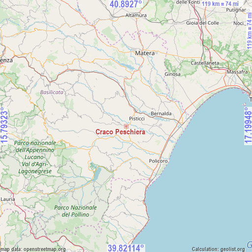
Craco Peschiera GPS coordinates[2]
40° 21' 32.58" North, 16° 29' 46.86" East
| Map corner | latitude | longitude |
|---|---|---|
| Upper-left | 40.8927°, | 15.79323° |
| Center: | 40.35905°, | 16.49635° |
| Lower-right: | 39.82114°, | 17.19948° |
| Map W x H: | 119.1×119.1 km | = 74×74mi |
| max Lat: | 47.04031° ⇑85.1% North |
| Craco Peschiera: | 40.35905° |
| min Lat: | ⇓14.9% South 35.50142° |
| min Long | Craco Peschiera | max Long |
| 6.69888° | 16.49635° | 18.48682° |
| W 96.4%⇐ | ⇒3.6% E |
Elevation
Elevation of Craco Peschiera is 83 m = 272 ft, and this is 223.7 m = 734 ft below average elevation for this country.
| Max E: |
2085 m = 6841 ft | 73% |
| Avg. | 306.7 m = 1006 ft | |
| Craco Peschiera | 83 m = 272 ft | |
Min E: |
-4 m = -13 ft | 27% |
See also: Italy elevation on elevation.city.
Geographical zone
Craco Peschiera is located in North temperate zone (between Tropic of Cancer and the Arctic Circle). Distance of this Northern Tropic circle is 1881.6 km =1169.2 mi to South.| Distance of | km | miles | from Craco Peschiera |
|---|---|---|---|
| North Pole | 5519.6 | 3429.7 | to North |
| Arctic Circle | 2913.7 | 1810.5 | to North |
| Tropic Cancer | 1881.6 | 1169.2 | to South |
| Equator | 4487.5 | 2788.4 | to South |


Nearby cities:
15 places around Craco Peschiera: (largest is in red/bold)
• Bernalda
17.4 km =10.8 mi,  69°
69°
• Colobraro
19.9 km =12.4 mi,  197°
197°
• Craco-Sant'Angelo
5.5 km =3.4 mi,  294°
294°
• Ferrandina
16.2 km =10.1 mi,  346°
346°
• Marconia
16.3 km =10.1 mi,  88°
88°
• Montalbano Jonico
10.2 km =6.3 mi,  142°
142°
• Pisticci
6.3 km =3.9 mi,  56°
56°
• Pisticci Scalo
8.2 km =5.1 mi,  33°
33°
• Policoro
22.4 km =13.9 mi, 136°
• Pomarico
19 km =11.8 mi,  7°
7°
• Rotondella
21 km =13 mi,  173°
173°
• Sant'Arcangelo
22.8 km =14.2 mi,  237°
237°
• Scanzano Jonico
20.9 km =13 mi,  125°
125°
• Tursi
12.7 km =7.9 mi,  189°
189°
• Valsinni
21.4 km =13.3 mi, 192°
Sources, notices
• [Note1] Compared only with cities in Italy existing in our database
• [Src1] Map data: © OpenStreetMap contributors (CC-BY-SA)
• [Src2] Other city data from geonames.org with taken over terms of usage.
• [Src3] Geographical zone / Annual Mean Temperature by Robert A. Rohde @ Wikipedia
