Salandra geodata
Salandra (Basilicate) is a seat of a third-order administrative division; located in Italy in Europe/Rome (GMT+2) time zone. With population of 2,598 people, there are 3417 cities with bigger population in this country. Compared to other cities in Italy, 84% of cities are located further ↑North; 95.4% of cities are located further ←West and 81.2% of cities have lower elevation than Salandra. Note1


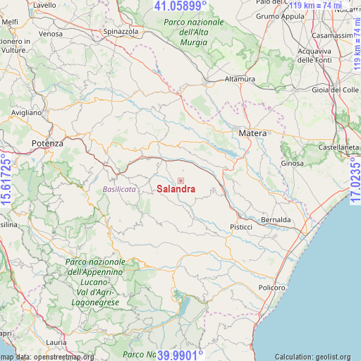
Salandra GPS coordinates[2]
40° 31' 36.048" North, 16° 19' 13.332" East
| Map corner | latitude | longitude |
|---|---|---|
| Upper-left | 41.05899°, | 15.61725° |
| Center: | 40.52668°, | 16.32037° |
| Lower-right: | 39.9901°, | 17.0235° |
| Map W x H: | 118.8×118.8 km | = 73.8×73.8mi |
| max Lat: | 47.04031° ⇑84% North |
| Salandra: | 40.52668° |
| min Lat: | ⇓16% South 35.50142° |
| min Long | Salandra | max Long |
| 6.69888° | 16.32037° | 18.48682° |
| W 95.4%⇐ | ⇒4.6% E |
Elevation
Elevation of Salandra is 542 m = 1778 ft, and this is 235.3 m = 772 ft above average elevation for this country.
| Max E: |
2085 m = 6841 ft | 18.8% |
| Salandra | 542 m 1778 ft | |
| Avg. | 306.7 m = 1006 ft | |
Min E: |
-4 m = -13 ft | 81.2% |
See also: Italy elevation on elevation.city.
Geographical zone
Salandra is located in North temperate zone (between Tropic of Cancer and the Arctic Circle). Distance of this Northern Tropic circle is 1900.2 km =1180.7 mi to South.| Distance of | km | miles | from Salandra |
|---|---|---|---|
| North Pole | 5500.9 | 3418.1 | to North |
| Arctic Circle | 2895 | 1798.9 | to North |
| Tropic Cancer | 1900.2 | 1180.7 | to South |
| Equator | 4506.1 | 2800 | to South |


Nearby cities:
15 places around Salandra: (largest is in red/bold)
• Accettura
14.3 km =8.9 mi,  253°
253°
• Calciano
12.8 km =8 mi,  302°
302°
• Cirigliano
19.4 km =12.1 mi,  220°
220°
• Craco-Sant'Angelo
19.1 km =11.9 mi,  148°
148°
• Ferrandina
11.5 km =7.1 mi,  104°
104°
• Garaguso
8.2 km =5.1 mi,  287°
287°
• Gorgoglione
20.8 km =12.9 mi,  225°
225°
• Grassano
12.5 km =7.8 mi,  343°
343°
• Grottole
9.8 km =6.1 mi,  29°
29°
• Miglionico
15.8 km =9.8 mi,  73°
73°
• Oliveto Lucano
11.4 km =7.1 mi,  274°
274°
• Pomarico
17.5 km =10.9 mi,  89°
89°
• San Mauro Forte
7.6 km =4.7 mi, 230°
• Stigliano
15.8 km =9.8 mi,  208°
208°
• Tricarico
17.9 km =11.1 mi, 303°
Sources, notices
• [Note1] Compared only with cities in Italy existing in our database
• [Src1] Map data: © OpenStreetMap contributors (CC-BY-SA)
• [Src2] Other city data from geonames.org with taken over terms of usage.
• [Src3] Geographical zone / Annual Mean Temperature by Robert A. Rohde @ Wikipedia
