Faicchio geodata
Faicchio (Campania) is a seat of a third-order administrative division; located in Italy in Europe/Rome (GMT+2) time zone. With population of 733 people, there are 8065 cities with bigger population in this country. Compared to other cities in Italy, 76.3% of cities are located further ↑North; 82.4% of cities are located further ←West and 57.9% of cities have higher elevation than Faicchio. Note1


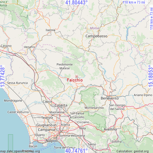
Faicchio GPS coordinates[2]
41° 16' 41.376" North, 14° 28' 38.64" East
| Map corner | latitude | longitude |
|---|---|---|
| Upper-left | 41.80443°, | 13.77428° |
| Center: | 41.27816°, | 14.4774° |
| Lower-right: | 40.74761°, | 15.18053° |
| Map W x H: | 117.5×117.5 km | = 73×73mi |
| max Lat: | 47.04031° ⇑76.3% North |
| Faicchio: | 41.27816° |
| min Lat: | ⇓23.7% South 35.50142° |
| min Long | Faicchio | max Long |
| 6.69888° | 14.4774° | 18.48682° |
| W 82.4%⇐ | ⇒17.6% E |
Elevation
Elevation of Faicchio is 180 m = 591 ft, and this is 126.7 m = 416 ft below average elevation for this country.
| Max E: |
2085 m = 6841 ft | 57.9% |
| Avg. | 306.7 m = 1006 ft | |
| Faicchio | 180 m = 591 ft | |
Min E: |
-4 m = -13 ft | 42.1% |
See also: Italy elevation on elevation.city.
Geographical zone
Faicchio is located in North temperate zone (between Tropic of Cancer and the Arctic Circle). Distance of this Northern Tropic circle is 1983.8 km =1232.7 mi to South.| Distance of | km | miles | from Faicchio |
|---|---|---|---|
| North Pole | 5417.4 | 3366.2 | to North |
| Arctic Circle | 2811.5 | 1747 | to North |
| Tropic Cancer | 1983.8 | 1232.7 | to South |
| Equator | 4589.7 | 2851.9 | to South |


Nearby cities:
15 places around Faicchio: (largest is in red/bold)
• Amorosi
8.4 km =5.2 mi,  186°
186°
• Castelvenere
7.6 km =4.7 mi,  129°
129°
• Cerreto Sannita
7 km =4.3 mi,  85°
85°
• Cusano Mutri
7 km =4.3 mi,  22°
22°
• Gioia Sannitica
3.7 km =2.3 mi,  310°
310°
• Guardia Sanframondi
10.4 km =6.5 mi,  103°
103°
• Pietraroja
9.8 km =6.1 mi,  37°
37°
• Puglianello
6.7 km =4.2 mi,  199°
199°
• Ruviano
9.4 km =5.8 mi,  216°
216°
• San Lorenzello
5.4 km =3.4 mi, 92°
• San Potito Sannitico
9.7 km =6 mi, 312°
• San Salvatore Telesino
5.1 km =3.2 mi,  159°
159°
• Telese
7.9 km =4.9 mi,  148°
148°
• Via Fausto Coppi
8.7 km =5.4 mi, 150°
• Via S. Giovanni
7.7 km =4.8 mi, 158°
Sources, notices
• [Note1] Compared only with cities in Italy existing in our database
• [Src1] Map data: © OpenStreetMap contributors (CC-BY-SA)
• [Src2] Other city data from geonames.org with taken over terms of usage.
• [Src3] Geographical zone / Annual Mean Temperature by Robert A. Rohde @ Wikipedia
