Erula geodata
Erula (Sardinia) is a seat of a third-order administrative division; located in Italy in Europe/Rome (GMT+2) time zone. With population of 507 people, there are 9858 cities with bigger population in this country. Compared to other cities in Italy, 81.4% of cities are located further ↑North; 82% of cities are located further →East and 74.6% of cities have lower elevation than Erula. Note1


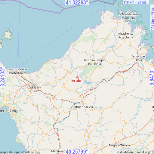
Erula GPS coordinates[2]
40° 47' 32.784" North, 8° 56' 39.048" East
| Map corner | latitude | longitude |
|---|---|---|
| Upper-left | 41.32263°, | 8.24105° |
| Center: | 40.79244°, | 8.94418° |
| Lower-right: | 40.25799°, | 9.6473° |
| Map W x H: | 118.4×118.4 km | = 73.6×73.6mi |
| max Lat: | 47.04031° ⇑81.4% North |
| Erula: | 40.79244° |
| min Lat: | ⇓18.6% South 35.50142° |
| min Long | Erula | max Long |
| 6.69888° | 8.94418° | 18.48682° |
| W 18%⇐ | ⇒82% E |
Elevation
Elevation of Erula is 447 m = 1467 ft, and this is 140.3 m = 460 ft above average elevation for this country.
| Max E: |
2085 m = 6841 ft | 25.4% |
| Erula | 447 m 1467 ft | |
| Avg. | 306.7 m = 1006 ft | |
Min E: |
-4 m = -13 ft | 74.6% |
See also: Italy elevation on elevation.city.
Geographical zone
Erula is located in North temperate zone (between Tropic of Cancer and the Arctic Circle). Distance of this Northern Tropic circle is 1929.8 km =1199.1 mi to South.| Distance of | km | miles | from Erula |
|---|---|---|---|
| North Pole | 5471.4 | 3399.8 | to North |
| Arctic Circle | 2865.5 | 1780.5 | to North |
| Tropic Cancer | 1929.8 | 1199.1 | to South |
| Equator | 4535.7 | 2818.4 | to South |


Nearby cities:
15 places around Erula: (largest is in red/bold)
• Bortigiadas
13.8 km =8.6 mi,  37°
37°
• Bulzi
11.3 km =7 mi,  302°
302°
• Chiaramonti
11.5 km =7.1 mi,  244°
244°
• Codaruina
18.2 km =11.3 mi,  326°
326°
• La Muddizza
17.7 km =11 mi,  317°
317°
• Laerru
9.5 km =5.9 mi,  286°
286°
• Martis
11.5 km =7.1 mi,  261°
261°
• Nulvi
16.9 km =10.5 mi,  266°
266°
• Oschiri
15.5 km =9.6 mi,  121°
121°
• Perfugas
6.8 km =4.2 mi,  310°
310°
• Santa Maria Coghinas
14.1 km =8.8 mi, 331°
• Sedini
12.7 km =7.9 mi, 302°
• Tempio Pausania
18.1 km =11.2 mi,  48°
48°
• Tula
7.5 km =4.7 mi,  153°
153°
• Viddalba
14.1 km =8.8 mi,  341°
341°
Sources, notices
• [Note1] Compared only with cities in Italy existing in our database
• [Src1] Map data: © OpenStreetMap contributors (CC-BY-SA)
• [Src2] Other city data from geonames.org with taken over terms of usage.
• [Src3] Geographical zone / Annual Mean Temperature by Robert A. Rohde @ Wikipedia
