Viddalba geodata
Viddalba (Sardinia) is a seat of a third-order administrative division; located in Italy in Europe/Rome (GMT+2) time zone. With population of 1,483 people, there are 5154 cities with bigger population in this country. Compared to other cities in Italy, 79.7% of cities are located further ↑North; 82.9% of cities are located further →East and 88.3% of cities have higher elevation than Viddalba. Note1


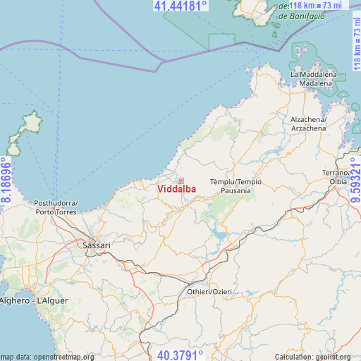
Viddalba GPS coordinates[2]
40° 54' 45.324" North, 8° 53' 24.324" East
| Map corner | latitude | longitude |
|---|---|---|
| Upper-left | 41.44181°, | 8.18696° |
| Center: | 40.91259°, | 8.89009° |
| Lower-right: | 40.3791°, | 9.59321° |
| Map W x H: | 118.2×118.2 km | = 73.4×73.4mi |
| max Lat: | 47.04031° ⇑79.7% North |
| Viddalba: | 40.91259° |
| min Lat: | ⇓20.3% South 35.50142° |
| min Long | Viddalba | max Long |
| 6.69888° | 8.89009° | 18.48682° |
| W 17.1%⇐ | ⇒82.9% E |
Elevation
Elevation of Viddalba is 22 m = 72 ft, and this is 284.7 m = 934 ft below average elevation for this country.
| Max E: |
2085 m = 6841 ft | 88.3% |
| Avg. | 306.7 m = 1006 ft | |
| Viddalba | 22 m = 72 ft | |
Min E: |
-4 m = -13 ft | 11.7% |
See also: Italy elevation on elevation.city.
Geographical zone
Viddalba is located in North temperate zone (between Tropic of Cancer and the Arctic Circle). Distance of this Northern Tropic circle is 1943.1 km =1207.4 mi to South.| Distance of | km | miles | from Viddalba |
|---|---|---|---|
| North Pole | 5458 | 3391.4 | to North |
| Arctic Circle | 2852.1 | 1772.2 | to North |
| Tropic Cancer | 1943.1 | 1207.4 | to South |
| Equator | 4549.1 | 2826.7 | to South |


Nearby cities:
15 places around Viddalba: (largest is in red/bold)
• Aggius
14.8 km =9.2 mi,  82°
82°
• Badesi
5.8 km =3.6 mi,  353°
353°
• Bortigiadas
13.1 km =8.1 mi,  100°
100°
• Bulzi
8.9 km =5.5 mi,  214°
214°
• Castelsardo
14.8 km =9.2 mi,  269°
269°
• Codaruina
5.8 km =3.6 mi,  287°
287°
• Erula
14.1 km =8.8 mi,  161°
161°
• La Muddizza
7.5 km =4.7 mi, 267°
• Laerru
11.5 km =7.1 mi,  202°
202°
• Perfugas
8.9 km =5.5 mi,  183°
183°
• Santa Maria Coghinas
2.4 km =1.5 mi,  247°
247°
• Sedini
9.1 km =5.7 mi,  222°
222°
• Trinità d'Agultu
8.4 km =5.2 mi,  13°
13°
• Trinità d'Agultu e Vignola
8.2 km =5.1 mi,  15°
15°
• Valledoria
5.9 km =3.7 mi, 287°
Sources, notices
• [Note1] Compared only with cities in Italy existing in our database
• [Src1] Map data: © OpenStreetMap contributors (CC-BY-SA)
• [Src2] Other city data from geonames.org with taken over terms of usage.
• [Src3] Geographical zone / Annual Mean Temperature by Robert A. Rohde @ Wikipedia
