Perfugas geodata
Perfugas (Sardinia) is a seat of a third-order administrative division; located in Italy in Europe/Rome (GMT+2) time zone. With population of 2,085 people, there are 4013 cities with bigger population in this country. Compared to other cities in Italy, 81% of cities are located further ↑North; 83% of cities are located further →East and 71.1% of cities have higher elevation than Perfugas. Note1


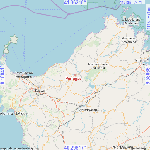
Perfugas GPS coordinates[2]
40° 49' 56.316" North, 8° 53' 0.744" East
| Map corner | latitude | longitude |
|---|---|---|
| Upper-left | 41.36218°, | 8.18041° |
| Center: | 40.83231°, | 8.88354° |
| Lower-right: | 40.29817°, | 9.58666° |
| Map W x H: | 118.3×118.3 km | = 73.5×73.5mi |
| max Lat: | 47.04031° ⇑81% North |
| Perfugas: | 40.83231° |
| min Lat: | ⇓19% South 35.50142° |
| min Long | Perfugas | max Long |
| 6.69888° | 8.88354° | 18.48682° |
| W 17%⇐ | ⇒83% E |
Elevation
Elevation of Perfugas is 92 m = 302 ft, and this is 214.7 m = 704 ft below average elevation for this country.
| Max E: |
2085 m = 6841 ft | 71.1% |
| Avg. | 306.7 m = 1006 ft | |
| Perfugas | 92 m = 302 ft | |
Min E: |
-4 m = -13 ft | 28.9% |
See also: Italy elevation on elevation.city.
Geographical zone
Perfugas is located in North temperate zone (between Tropic of Cancer and the Arctic Circle). Distance of this Northern Tropic circle is 1934.2 km =1201.9 mi to South.| Distance of | km | miles | from Perfugas |
|---|---|---|---|
| North Pole | 5466.9 | 3397 | to North |
| Arctic Circle | 2861 | 1777.7 | to North |
| Tropic Cancer | 1934.2 | 1201.9 | to South |
| Equator | 4540.1 | 2821.1 | to South |


Nearby cities:
15 places around Perfugas: (largest is in red/bold)
• Badesi
14.7 km =9.1 mi,  359°
359°
• Bulzi
4.8 km =3 mi,  289°
289°
• Chiaramonti
10.7 km =6.6 mi,  209°
209°
• Codaruina
11.8 km =7.3 mi,  334°
334°
• Erula
6.8 km =4.2 mi,  130°
130°
• La Muddizza
11 km =6.8 mi,  321°
321°
• Laerru
4.3 km =2.7 mi,  246°
246°
• Martis
8.7 km =5.4 mi,  226°
226°
• Nulvi
12.9 km =8 mi, 245°
• Santa Maria Coghinas
8.2 km =5.1 mi,  348°
348°
• Sedini
6.1 km =3.8 mi, 292°
• Tergu
14.7 km =9.1 mi,  284°
284°
• Tula
14 km =8.7 mi,  142°
142°
• Valledoria
11.9 km =7.4 mi, 334°
• Viddalba
8.9 km =5.5 mi,  3°
3°
Sources, notices
• [Note1] Compared only with cities in Italy existing in our database
• [Src1] Map data: © OpenStreetMap contributors (CC-BY-SA)
• [Src2] Other city data from geonames.org with taken over terms of usage.
• [Src3] Geographical zone / Annual Mean Temperature by Robert A. Rohde @ Wikipedia
