Dosimo geodata
Dosimo (Lombardy) is a seat of a third-order administrative division; located in Italy in Europe/Rome (GMT+2) time zone. With population of 834 people, there are 7481 cities with bigger population in this country. Compared to other cities in Italy, 64.6% of cities are located further ↓South; 66.9% of cities are located further →East and 81.2% of cities have higher elevation than Dosimo. Note1
Administrative division(s):
- Level 1: Lombardy
- Level 2: Provincia di Cremona
- Level 3: Gadesco-Pieve Delmona


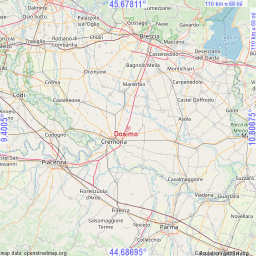
Dosimo GPS coordinates[2]
45° 11' 4.884" North, 10° 6' 13.032" East
| Map corner | latitude | longitude |
|---|---|---|
| Upper-left | 45.67811°, | 9.4005° |
| Center: | 45.18469°, | 10.10362° |
| Lower-right: | 44.68695°, | 10.80675° |
| Map W x H: | 110.2×110.2 km | = 68.5×68.5mi |
| max Lat: | 47.04031° ⇑35.4% North |
| Dosimo: | 45.18469° |
| min Lat: | ⇓64.6% South 35.50142° |
| min Long | Dosimo | max Long |
| 6.69888° | 10.10362° | 18.48682° |
| W 33.1%⇐ | ⇒66.9% E |
Elevation
Elevation of Dosimo is 45 m = 148 ft, and this is 261.7 m = 859 ft below average elevation for this country.
| Max E: |
2085 m = 6841 ft | 81.2% |
| Avg. | 306.7 m = 1006 ft | |
| Dosimo | 45 m = 148 ft | |
Min E: |
-4 m = -13 ft | 18.8% |
See also: Italy elevation on elevation.city.
Geographical zone
Dosimo is located in North temperate zone (between Tropic of Cancer and the Arctic Circle). Distance of this North polar circle is 2377.1 km =1477.1 mi to North.| Distance of | km | miles | from Dosimo |
|---|---|---|---|
| North Pole | 4983 | 3096.3 | to North |
| Arctic Circle | 2377.1 | 1477.1 | to North |
| Tropic Cancer | 2418.1 | 1502.5 | to South |
| Equator | 5024.1 | 3121.8 | to South |


Nearby cities:
15 places around Dosimo: (largest is in red/bold)
• Ardole San Marino
3.2 km =2 mi,  177°
177°
• Boschetto
6.4 km =4 mi,  250°
250°
• Cicognolo
7.3 km =4.5 mi,  104°
104°
• Corte de' Frati
3.8 km =2.4 mi,  357°
357°
• Gadesco-Pieve Delmona
3.1 km =1.9 mi,  162°
162°
• Grontardo
4.2 km =2.6 mi,  63°
63°
• Malagnino
5.6 km =3.5 mi,  171°
171°
• Maristella
5.5 km =3.4 mi,  226°
226°
• Persico Dosimo
0.2 km =0.1 mi,  42°
42°
• Pescarolo
6.6 km =4.1 mi,  81°
81°
• Pozzaglio
4.3 km =2.7 mi,  293°
293°
• Pozzaglio ed Uniti
4.5 km =2.8 mi, 292°
• San Felice
5.2 km =3.2 mi,  206°
206°
• Scandolara Ripa d'Oglio
5.9 km =3.7 mi,  45°
45°
• Vescovato
4.9 km =3 mi, 103°
Sources, notices
• [Note1] Compared only with cities in Italy existing in our database
• [Src1] Map data: © OpenStreetMap contributors (CC-BY-SA)
• [Src2] Other city data from geonames.org with taken over terms of usage.
• [Src3] Geographical zone / Annual Mean Temperature by Robert A. Rohde @ Wikipedia
