Malagnino geodata
Malagnino (Lombardy) is a seat of a third-order administrative division; located in Italy in Europe/Rome (GMT+2) time zone. With population of 858 people, there are 7366 cities with bigger population in this country. Compared to other cities in Italy, 63.3% of cities are located further ↓South; 66.7% of cities are located further →East and 82% of cities have higher elevation than Malagnino. Note1


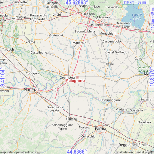
Malagnino GPS coordinates[2]
45° 8' 5.172" North, 10° 6' 53.172" East
| Map corner | latitude | longitude |
|---|---|---|
| Upper-left | 45.62863°, | 9.41164° |
| Center: | 45.13477°, | 10.11477° |
| Lower-right: | 44.6366°, | 10.8179° |
| Map W x H: | 110.3×110.3 km | = 68.5×68.5mi |
| max Lat: | 47.04031° ⇑36.7% North |
| Malagnino: | 45.13477° |
| min Lat: | ⇓63.3% South 35.50142° |
| min Long | Malagnino | max Long |
| 6.69888° | 10.11477° | 18.48682° |
| W 33.3%⇐ | ⇒66.7% E |
Elevation
Elevation of Malagnino is 42 m = 138 ft, and this is 264.7 m = 868 ft below average elevation for this country.
| Max E: |
2085 m = 6841 ft | 82% |
| Avg. | 306.7 m = 1006 ft | |
| Malagnino | 42 m = 138 ft | |
Min E: |
-4 m = -13 ft | 18% |
See also: Italy elevation on elevation.city.
Geographical zone
Malagnino is located in North temperate zone (between Tropic of Cancer and the Arctic Circle). Distance of this North polar circle is 2382.7 km =1480.5 mi to North.| Distance of | km | miles | from Malagnino |
|---|---|---|---|
| North Pole | 4988.5 | 3099.7 | to North |
| Arctic Circle | 2382.7 | 1480.5 | to North |
| Tropic Cancer | 2412.6 | 1499.1 | to South |
| Equator | 5018.5 | 3118.4 | to South |


Nearby cities:
15 places around Malagnino: (largest is in red/bold)
• Ardole San Marino
2.5 km =1.6 mi,  343°
343°
• Battaglione-Bagnara
4.3 km =2.7 mi,  241°
241°
• Bonemerse
3.8 km =2.4 mi,  231°
231°
• Bosco Ex Parmigiano
6.7 km =4.2 mi, 242°
• Dosimo
5.6 km =3.5 mi,  351°
351°
• Gadesco-Pieve Delmona
2.5 km =1.6 mi,  1°
1°
• Gerre de' Caprioli
7 km =4.3 mi, 225°
• Maristella
5.2 km =3.2 mi,  290°
290°
• Persico Dosimo
5.7 km =3.5 mi, 352°
• Pieve San Giacomo
5.7 km =3.5 mi,  93°
93°
• Pieve d'Olmi
5.1 km =3.2 mi,  172°
172°
• San Felice
3.3 km =2.1 mi, 285°
• Sospiro
4.6 km =2.9 mi,  131°
131°
• Stagno Lombardo
7 km =4.3 mi,  196°
196°
• Vescovato
5.9 km =3.7 mi,  41°
41°
Sources, notices
• [Note1] Compared only with cities in Italy existing in our database
• [Src1] Map data: © OpenStreetMap contributors (CC-BY-SA)
• [Src2] Other city data from geonames.org with taken over terms of usage.
• [Src3] Geographical zone / Annual Mean Temperature by Robert A. Rohde @ Wikipedia
