Maristella geodata
Maristella (Lombardy) is a populated place; located in Italy in Europe/Rome (GMT+2) time zone. With population of 898 people, there are 7164 cities with bigger population in this country. Compared to other cities in Italy, 63.8% of cities are located further ↓South; 67.3% of cities are located further →East and 81.5% of cities have higher elevation than Maristella. Note1


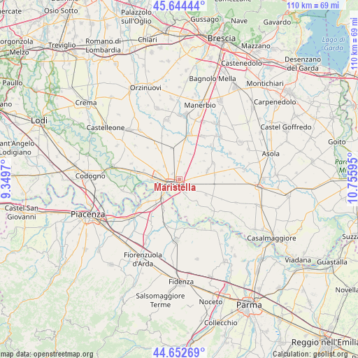
Maristella GPS coordinates[2]
45° 9' 2.592" North, 10° 3' 10.152" East
| Map corner | latitude | longitude |
|---|---|---|
| Upper-left | 45.64444°, | 9.3497° |
| Center: | 45.15072°, | 10.05282° |
| Lower-right: | 44.65269°, | 10.75595° |
| Map W x H: | 110.3×110.3 km | = 68.5×68.5mi |
| max Lat: | 47.04031° ⇑36.2% North |
| Maristella: | 45.15072° |
| min Lat: | ⇓63.8% South 35.50142° |
| min Long | Maristella | max Long |
| 6.69888° | 10.05282° | 18.48682° |
| W 32.7%⇐ | ⇒67.3% E |
Elevation
Elevation of Maristella is 44 m = 144 ft, and this is 262.7 m = 862 ft below average elevation for this country.
| Max E: |
2085 m = 6841 ft | 81.5% |
| Avg. | 306.7 m = 1006 ft | |
| Maristella | 44 m = 144 ft | |
Min E: |
-4 m = -13 ft | 18.5% |
See also: Italy elevation on elevation.city.
Geographical zone
Maristella is located in North temperate zone (between Tropic of Cancer and the Arctic Circle). Distance of this North polar circle is 2380.9 km =1479.4 mi to North.| Distance of | km | miles | from Maristella |
|---|---|---|---|
| North Pole | 4986.8 | 3098.7 | to North |
| Arctic Circle | 2380.9 | 1479.4 | to North |
| Tropic Cancer | 2414.4 | 1500.2 | to South |
| Equator | 5020.3 | 3119.5 | to South |


Nearby cities:
15 places around Maristella: (largest is in red/bold)
• Ardole San Marino
4.2 km =2.6 mi,  81°
81°
• Battaglione-Bagnara
4 km =2.5 mi,  163°
163°
• Bonemerse
4.6 km =2.9 mi,  154°
154°
• Boschetto
2.7 km =1.7 mi,  309°
309°
• Bosco Ex Parmigiano
5 km =3.1 mi,  192°
192°
• Castelverde
6 km =3.7 mi, 313°
• Cremona
3.1 km =1.9 mi,  231°
231°
• Dosimo
5.5 km =3.4 mi,  46°
46°
• Gadesco-Pieve Delmona
5 km =3.1 mi, 81°
• Gerre de' Caprioli
6.7 km =4.2 mi,  181°
181°
• Malagnino
5.2 km =3.2 mi,  110°
110°
• Persico Dosimo
5.7 km =3.5 mi, 46°
• Pozzaglio
5.5 km =3.4 mi,  0°
0°
• Pozzaglio ed Uniti
5.5 km =3.4 mi,  358°
358°
• San Felice
1.9 km =1.2 mi,  117°
117°
Sources, notices
• [Note1] Compared only with cities in Italy existing in our database
• [Src1] Map data: © OpenStreetMap contributors (CC-BY-SA)
• [Src2] Other city data from geonames.org with taken over terms of usage.
• [Src3] Geographical zone / Annual Mean Temperature by Robert A. Rohde @ Wikipedia
