Crodo geodata
Crodo (Piedmont) is a seat of a third-order administrative division; located in Italy in Europe/Rome (GMT+1) time zone. With population of 871 people, there are 7307 cities with bigger population in this country. Compared to other cities in Italy, 96.2% of cities are located further ↓South; 89.9% of cities are located further →East and 78.9% of cities have lower elevation than Crodo. Note1
Administrative division(s):
- Level 1: Piedmont
- Level 2: Provincia Verbano-Cusio-Ossola
- Level 3: Crodo


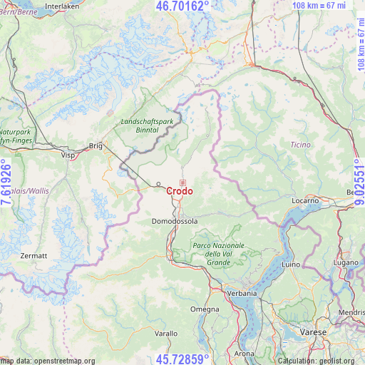
Crodo GPS coordinates[2]
46° 13' 2.136" North, 8° 19' 20.568" East
| Map corner | latitude | longitude |
|---|---|---|
| Upper-left | 46.70162°, | 7.61926° |
| Center: | 46.21726°, | 8.32238° |
| Lower-right: | 45.72859°, | 9.02551° |
| Map W x H: | 108.2×108.2 km | = 67.2×67.2mi |
| max Lat: | 47.04031° ⇑3.8% North |
| Crodo: | 46.21726° |
| min Lat: | ⇓96.2% South 35.50142° |
| min Long | Crodo | max Long |
| 6.69888° | 8.32238° | 18.48682° |
| W 10.1%⇐ | ⇒89.9% E |
Elevation
Elevation of Crodo is 506 m = 1660 ft, and this is 199.3 m = 654 ft above average elevation for this country.
| Max E: |
2085 m = 6841 ft | 21.1% |
| Crodo | 506 m 1660 ft | |
| Avg. | 306.7 m = 1006 ft | |
Min E: |
-4 m = -13 ft | 78.9% |
See also: Italy elevation on elevation.city.
Geographical zone
Crodo is located in North temperate zone (between Tropic of Cancer and the Arctic Circle). Distance of this North polar circle is 2262.3 km =1405.7 mi to North.| Distance of | km | miles | from Crodo |
|---|---|---|---|
| North Pole | 4868.2 | 3025 | to North |
| Arctic Circle | 2262.3 | 1405.7 | to North |
| Tropic Cancer | 2533 | 1573.9 | to South |
| Equator | 5138.9 | 3193.2 | to South |


Nearby cities:
15 places around Crodo: (largest is in red/bold)
• Baceno
4.8 km =3 mi,  356°
356°
• Crevoladossola
7.9 km =4.9 mi,  194°
194°
• Croppo
12.8 km =8 mi,  184°
184°
• Domodossola
11.4 km =7.1 mi, 191°
• Druogno
12.5 km =7.8 mi,  137°
137°
• Masera
8.7 km =5.4 mi, 178°
• Montecrestese
5.9 km =3.7 mi, 177°
• Pontetto-Roldo
7.3 km =4.5 mi, 180°
• Premia
5.8 km =3.6 mi,  12°
12°
• San Lorenzo
13.7 km =8.5 mi,  223°
223°
• Santa Maria Maggiore
13.9 km =8.6 mi,  129°
129°
• Toceno
13.9 km =8.6 mi, 125°
• Trasquera
8.4 km =5.2 mi,  267°
267°
• Trontano
10.6 km =6.6 mi, 175°
• Varzo
5.5 km =3.4 mi,  258°
258°
Sources, notices
• [Note1] Compared only with cities in Italy existing in our database
• [Src1] Map data: © OpenStreetMap contributors (CC-BY-SA)
• [Src2] Other city data from geonames.org with taken over terms of usage.
• [Src3] Geographical zone / Annual Mean Temperature by Robert A. Rohde @ Wikipedia
