Baceno geodata
Baceno (Piedmont) is a seat of a third-order administrative division; located in Italy in Europe/Rome (GMT+2) time zone. With population of 420 people, there are 10199 cities with bigger population in this country. Compared to other cities in Italy, 96.5% of cities are located further ↓South; 89.9% of cities are located further →East and 86.5% of cities have lower elevation than Baceno. Note1
Administrative division(s):
- Level 1: Piedmont
- Level 2: Provincia Verbano-Cusio-Ossola
- Level 3: Baceno


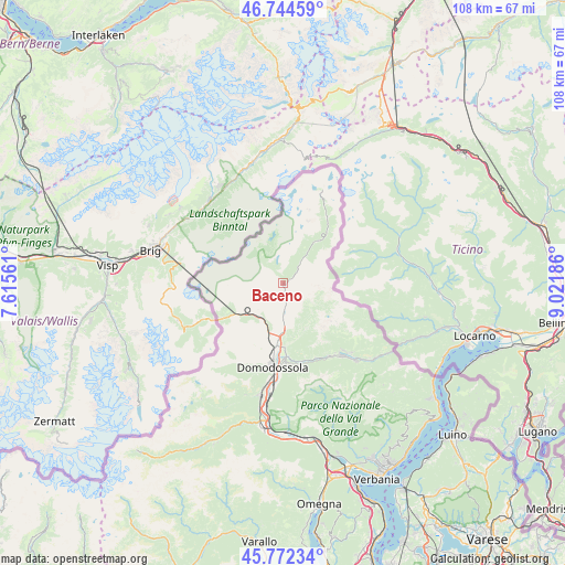
Baceno GPS coordinates[2]
46° 15' 38.232" North, 8° 19' 7.464" East
| Map corner | latitude | longitude |
|---|---|---|
| Upper-left | 46.74459°, | 7.61561° |
| Center: | 46.26062°, | 8.31874° |
| Lower-right: | 45.77234°, | 9.02186° |
| Map W x H: | 108.1×108.1 km | = 67.2×67.2mi |
| max Lat: | 47.04031° ⇑3.5% North |
| Baceno: | 46.26062° |
| min Lat: | ⇓96.5% South 35.50142° |
| min Long | Baceno | max Long |
| 6.69888° | 8.31874° | 18.48682° |
| W 10.1%⇐ | ⇒89.9% E |
Elevation
Elevation of Baceno is 642 m = 2106 ft, and this is 335.3 m = 1100 ft above average elevation for this country.
| Max E: |
2085 m = 6841 ft | 13.5% |
| Baceno | 642 m 2106 ft | |
| Avg. | 306.7 m = 1006 ft | |
Min E: |
-4 m = -13 ft | 86.5% |
See also: Italy elevation on elevation.city.
Geographical zone
Baceno is located in North temperate zone (between Tropic of Cancer and the Arctic Circle). Distance of this North polar circle is 2257.5 km =1402.7 mi to North.| Distance of | km | miles | from Baceno |
|---|---|---|---|
| North Pole | 4863.4 | 3022 | to North |
| Arctic Circle | 2257.5 | 1402.7 | to North |
| Tropic Cancer | 2537.8 | 1576.9 | to South |
| Equator | 5143.7 | 3196.1 | to South |


Nearby cities:
15 places around Baceno: (largest is in red/bold)
• Crevoladossola
12.6 km =7.8 mi,  187°
187°
• Crodo
4.8 km =3 mi,  176°
176°
• Domodossola
16.1 km =10 mi, 187°
• Druogno
16.6 km =10.3 mi,  148°
148°
• Formazza
15.3 km =9.5 mi,  32°
32°
• Masera
13.5 km =8.4 mi, 177°
• Montecrestese
10.7 km =6.6 mi, 176°
• Pontetto-Roldo
12.1 km =7.5 mi, 179°
• Premia
1.7 km =1.1 mi,  61°
61°
• San Lorenzo
17.4 km =10.8 mi,  211°
211°
• Santa Maria Maggiore
17.6 km =10.9 mi,  141°
141°
• Toceno
17.3 km =10.7 mi, 138°
• Trasquera
9.7 km =6 mi,  237°
237°
• Trontano
15.4 km =9.6 mi, 175°
• Varzo
7.8 km =4.8 mi,  220°
220°
Sources, notices
• [Note1] Compared only with cities in Italy existing in our database
• [Src1] Map data: © OpenStreetMap contributors (CC-BY-SA)
• [Src2] Other city data from geonames.org with taken over terms of usage.
• [Src3] Geographical zone / Annual Mean Temperature by Robert A. Rohde @ Wikipedia
