Comunanza geodata
Comunanza (The Marches) is a seat of a third-order administrative division; located in Italy in Europe/Rome (GMT+2) time zone. With population of 2,452 people, there are 3583 cities with bigger population in this country. Compared to other cities in Italy, 63.6% of cities are located further ↑North; 72.5% of cities are located further ←West and 75.1% of cities have lower elevation than Comunanza. Note1
Administrative division(s):
- Level 1: The Marches
- Level 2: Provincia di Ascoli Piceno
- Level 3: Comunanza


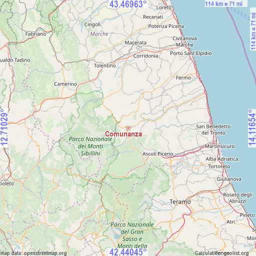
Comunanza GPS coordinates[2]
42° 57' 25.884" North, 13° 24' 48.276" East
| Map corner | latitude | longitude |
|---|---|---|
| Upper-left | 43.46963°, | 12.71029° |
| Center: | 42.95719°, | 13.41341° |
| Lower-right: | 42.44045°, | 14.11654° |
| Map W x H: | 114.4×114.4 km | = 71.1×71.1mi |
| max Lat: | 47.04031° ⇑63.6% North |
| Comunanza: | 42.95719° |
| min Lat: | ⇓36.4% South 35.50142° |
| min Long | Comunanza | max Long |
| 6.69888° | 13.41341° | 18.48682° |
| W 72.5%⇐ | ⇒27.5% E |
Elevation
Elevation of Comunanza is 453 m = 1486 ft, and this is 146.3 m = 480 ft above average elevation for this country.
| Max E: |
2085 m = 6841 ft | 24.9% |
| Comunanza | 453 m 1486 ft | |
| Avg. | 306.7 m = 1006 ft | |
Min E: |
-4 m = -13 ft | 75.1% |
See also: Italy elevation on elevation.city.
Geographical zone
Comunanza is located in North temperate zone (between Tropic of Cancer and the Arctic Circle). Distance of this Northern Tropic circle is 2170.5 km =1348.7 mi to South.| Distance of | km | miles | from Comunanza |
|---|---|---|---|
| North Pole | 5230.7 | 3250.2 | to North |
| Arctic Circle | 2624.8 | 1631 | to North |
| Tropic Cancer | 2170.5 | 1348.7 | to South |
| Equator | 4776.4 | 2967.9 | to South |


Nearby cities:
15 places around Comunanza: (largest is in red/bold)
• Amandola
5.3 km =3.3 mi,  296°
296°
• Force
6.1 km =3.8 mi,  86°
86°
• Marsia
11.9 km =7.4 mi,  154°
154°
• Monte San Martino
8.6 km =5.3 mi,  14°
14°
• Monte Vidon Combatte
9 km =5.6 mi,  19°
19°
• Montefalcone Appennino
5.1 km =3.2 mi,  44°
44°
• Montefortino
5.8 km =3.6 mi,  254°
254°
• Montelparo
12.1 km =7.5 mi,  56°
56°
• Montemonaco
9.4 km =5.8 mi,  226°
226°
• Palmiano
7.4 km =4.6 mi, 149°
• Penna San Giovanni
11 km =6.8 mi, 5°
• Rotella
11.8 km =7.3 mi, 91°
• San Vittoria in Matenano
9.7 km =6 mi, 44°
• Smerillo
5.9 km =3.7 mi,  25°
25°
• Venarotta
10.4 km =6.5 mi,  142°
142°
Sources, notices
• [Note1] Compared only with cities in Italy existing in our database
• [Src1] Map data: © OpenStreetMap contributors (CC-BY-SA)
• [Src2] Other city data from geonames.org with taken over terms of usage.
• [Src3] Geographical zone / Annual Mean Temperature by Robert A. Rohde @ Wikipedia
