Venarotta geodata
Venarotta (The Marches) is a seat of a third-order administrative division; located in Italy in Europe/Rome (GMT+2) time zone. With population of 1,091 people, there are 6324 cities with bigger population in this country. Compared to other cities in Italy, 64.1% of cities are located further ↑North; 73.5% of cities are located further ←West and 73.1% of cities have lower elevation than Venarotta. Note1
Administrative division(s):
- Level 1: The Marches
- Level 2: Provincia di Ascoli Piceno
- Level 3: Venarotta


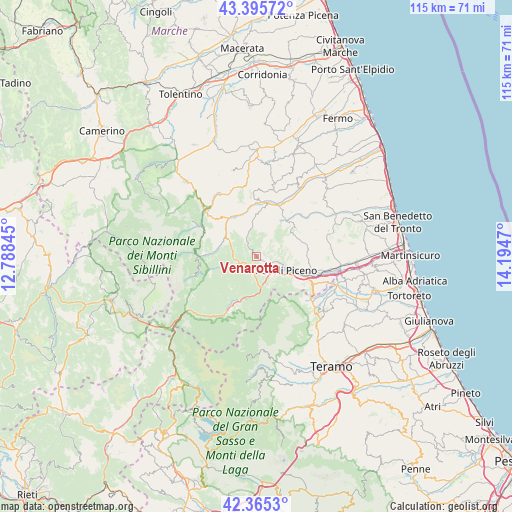
Venarotta GPS coordinates[2]
42° 52' 57.576" North, 13° 29' 29.652" East
| Map corner | latitude | longitude |
|---|---|---|
| Upper-left | 43.39572°, | 12.78845° |
| Center: | 42.88266°, | 13.49157° |
| Lower-right: | 42.3653°, | 14.1947° |
| Map W x H: | 114.6×114.6 km | = 71.2×71.2mi |
| max Lat: | 47.04031° ⇑64.1% North |
| Venarotta: | 42.88266° |
| min Lat: | ⇓35.9% South 35.50142° |
| min Long | Venarotta | max Long |
| 6.69888° | 13.49157° | 18.48682° |
| W 73.5%⇐ | ⇒26.5% E |
Elevation
Elevation of Venarotta is 426 m = 1398 ft, and this is 119.3 m = 391 ft above average elevation for this country.
| Max E: |
2085 m = 6841 ft | 26.9% |
| Venarotta | 426 m 1398 ft | |
| Avg. | 306.7 m = 1006 ft | |
Min E: |
-4 m = -13 ft | 73.1% |
See also: Italy elevation on elevation.city.
Geographical zone
Venarotta is located in North temperate zone (between Tropic of Cancer and the Arctic Circle). Distance of this Northern Tropic circle is 2162.2 km =1343.5 mi to South.| Distance of | km | miles | from Venarotta |
|---|---|---|---|
| North Pole | 5239 | 3255.4 | to North |
| Arctic Circle | 2633.1 | 1636.1 | to North |
| Tropic Cancer | 2162.2 | 1343.5 | to South |
| Equator | 4768.1 | 2962.8 | to South |


Nearby cities:
15 places around Venarotta: (largest is in red/bold)
• Ascoli Piceno
7.5 km =4.7 mi,  115°
115°
• Castignano
12.6 km =7.8 mi,  59°
59°
• Comunanza
10.4 km =6.5 mi,  322°
322°
• Force
8.7 km =5.4 mi,  357°
357°
• Marsia
2.8 km =1.7 mi,  206°
206°
• Montedinove
12.8 km =8 mi,  38°
38°
• Montefalcone Appennino
12.3 km =7.6 mi,  346°
346°
• Mozzano
6.1 km =3.8 mi,  164°
164°
• Paggese-Santa Maria
13.1 km =8.1 mi, 207°
• Palmiano
3.2 km =2 mi,  305°
305°
• Piagge
8.5 km =5.3 mi,  125°
125°
• Ripaberarda
10.1 km =6.3 mi,  65°
65°
• Rotella
9.7 km =6 mi,  34°
34°
• Venagrande
4.3 km =2.7 mi,  77°
77°
• Villa Pigna
12.9 km =8 mi, 115°
Sources, notices
• [Note1] Compared only with cities in Italy existing in our database
• [Src1] Map data: © OpenStreetMap contributors (CC-BY-SA)
• [Src2] Other city data from geonames.org with taken over terms of usage.
• [Src3] Geographical zone / Annual Mean Temperature by Robert A. Rohde @ Wikipedia
