Amandola geodata
Amandola (The Marches) is a seat of a third-order administrative division; located in Italy in Europe/Rome (GMT+2) time zone. With population of 1,871 people, there are 4369 cities with bigger population in this country. Compared to other cities in Italy, 63.5% of cities are located further ↑North; 72% of cities are located further ←West and 76.9% of cities have lower elevation than Amandola. Note1


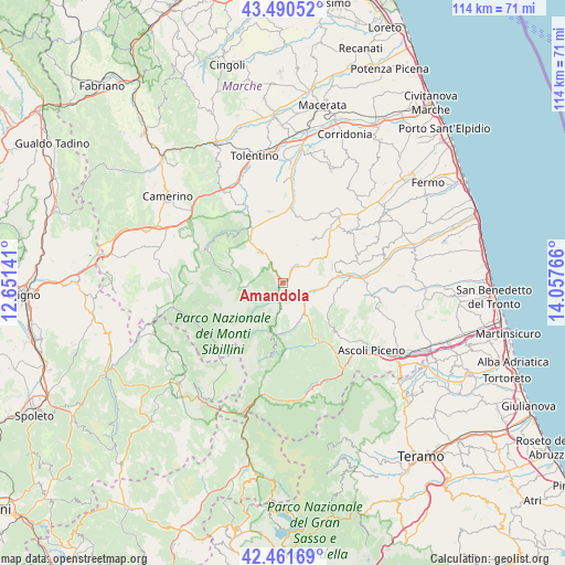
Amandola GPS coordinates[2]
42° 58' 41.736" North, 13° 21' 16.308" East
| Map corner | latitude | longitude |
|---|---|---|
| Upper-left | 43.49052°, | 12.65141° |
| Center: | 42.97826°, | 13.35453° |
| Lower-right: | 42.46169°, | 14.05766° |
| Map W x H: | 114.4×114.4 km | = 71.1×71.1mi |
| max Lat: | 47.04031° ⇑63.5% North |
| Amandola: | 42.97826° |
| min Lat: | ⇓36.5% South 35.50142° |
| min Long | Amandola | max Long |
| 6.69888° | 13.35453° | 18.48682° |
| W 72%⇐ | ⇒28% E |
Elevation
Elevation of Amandola is 478 m = 1568 ft, and this is 171.3 m = 562 ft above average elevation for this country.
| Max E: |
2085 m = 6841 ft | 23.1% |
| Amandola | 478 m 1568 ft | |
| Avg. | 306.7 m = 1006 ft | |
Min E: |
-4 m = -13 ft | 76.9% |
See also: Italy elevation on elevation.city.
Geographical zone
Amandola is located in North temperate zone (between Tropic of Cancer and the Arctic Circle). Distance of this Northern Tropic circle is 2172.8 km =1350.1 mi to South.| Distance of | km | miles | from Amandola |
|---|---|---|---|
| North Pole | 5228.3 | 3248.7 | to North |
| Arctic Circle | 2622.4 | 1629.5 | to North |
| Tropic Cancer | 2172.8 | 1350.1 | to South |
| Equator | 4778.7 | 2969.3 | to South |


Nearby cities:
15 places around Amandola: (largest is in red/bold)
• Bolognola
10.5 km =6.5 mi,  279°
279°
• Comunanza
5.3 km =3.3 mi,  116°
116°
• Force
11 km =6.8 mi,  100°
100°
• Gualdo
9.8 km =6.1 mi,  354°
354°
• Monte San Martino
9.2 km =5.7 mi,  49°
49°
• Monte Vidon Combatte
9.9 km =6.2 mi, 51°
• Montefalcone Appennino
8.4 km =5.2 mi,  81°
81°
• Montefortino
4 km =2.5 mi,  192°
192°
• Montemonaco
9.1 km =5.7 mi, 192°
• Palmiano
12.2 km =7.6 mi,  135°
135°
• Penna San Giovanni
10.4 km =6.5 mi,  33°
33°
• San Vittoria in Matenano
12.4 km =7.7 mi,  68°
68°
• Sant'Angelo in Pontano
13.7 km =8.5 mi,  14°
14°
• Sarnano
7.8 km =4.8 mi,  323°
323°
• Smerillo
7.9 km =4.9 mi, 67°
Sources, notices
• [Note1] Compared only with cities in Italy existing in our database
• [Src1] Map data: © OpenStreetMap contributors (CC-BY-SA)
• [Src2] Other city data from geonames.org with taken over terms of usage.
• [Src3] Geographical zone / Annual Mean Temperature by Robert A. Rohde @ Wikipedia
