Colleferro geodata
Colleferro (Latium) is a seat of a third-order administrative division; located in Italy in Europe/Rome (GMT+2) time zone. With population of 20,736 people, there are 423 cities with bigger population in this country. Compared to other cities in Italy, 72.6% of cities are located further ↑North; 68.3% of cities are located further ←West and 50.2% of cities have higher elevation than Colleferro. Note1
Administrative division(s):
- Level 1: Latium
- Level 2: Città metropolitana di Roma Capitale
- Level 3: Colleferro


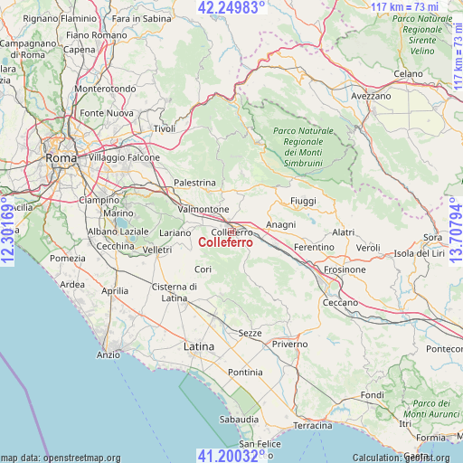
Colleferro GPS coordinates[2]
41° 43' 37.992" North, 13° 0' 17.316" East
| Map corner | latitude | longitude |
|---|---|---|
| Upper-left | 42.24983°, | 12.30169° |
| Center: | 41.72722°, | 13.00481° |
| Lower-right: | 41.20032°, | 13.70794° |
| Map W x H: | 116.7×116.7 km | = 72.5×72.5mi |
| max Lat: | 47.04031° ⇑72.6% North |
| Colleferro: | 41.72722° |
| min Lat: | ⇓27.4% South 35.50142° |
| min Long | Colleferro | max Long |
| 6.69888° | 13.00481° | 18.48682° |
| W 68.3%⇐ | ⇒31.7% E |
Elevation
Elevation of Colleferro is 234 m = 768 ft, and this is 72.7 m = 239 ft below average elevation for this country.
| Max E: |
2085 m = 6841 ft | 50.2% |
| Avg. | 306.7 m = 1006 ft | |
| Colleferro | 234 m = 768 ft | |
Min E: |
-4 m = -13 ft | 49.8% |
See also: Italy elevation on elevation.city.
Geographical zone
Colleferro is located in North temperate zone (between Tropic of Cancer and the Arctic Circle). Distance of this Northern Tropic circle is 2033.7 km =1263.7 mi to South.| Distance of | km | miles | from Colleferro |
|---|---|---|---|
| North Pole | 5367.4 | 3335.1 | to North |
| Arctic Circle | 2761.5 | 1715.9 | to North |
| Tropic Cancer | 2033.7 | 1263.7 | to South |
| Equator | 4639.6 | 2882.9 | to South |


Nearby cities:
15 places around Colleferro: (largest is in red/bold)
• Artena
8.3 km =5.2 mi,  280°
280°
• Cave
11.3 km =7 mi,  331°
331°
• Colubro
11.4 km =7.1 mi,  274°
274°
• Cruci
8.1 km =5 mi,  324°
324°
• Gavignano
4.9 km =3 mi,  129°
129°
• Genazzano
11.5 km =7.1 mi,  346°
346°
• Giulianello
11.4 km =7.1 mi,  246°
246°
• Gorga
11.7 km =7.3 mi, 133°
• Montelanico
9 km =5.6 mi,  160°
160°
• Osteria della Fontana
11.5 km =7.1 mi,  89°
89°
• Paliano
8.3 km =5.2 mi,  45°
45°
• Rocca Massima
8.8 km =5.5 mi,  232°
232°
• Segni
4.4 km =2.7 mi, 164°
• Valmontone
8.8 km =5.5 mi,  305°
305°
• Via Latina Iv Km
3.7 km =2.3 mi, 283°
Sources, notices
• [Note1] Compared only with cities in Italy existing in our database
• [Src1] Map data: © OpenStreetMap contributors (CC-BY-SA)
• [Src2] Other city data from geonames.org with taken over terms of usage.
• [Src3] Geographical zone / Annual Mean Temperature by Robert A. Rohde @ Wikipedia
