Colere geodata
Colere (Lombardy) is a seat of a third-order administrative division; located in Italy in Europe/Rome (GMT+2) time zone. With population of 805 people, there are 7620 cities with bigger population in this country. Compared to other cities in Italy, 91.3% of cities are located further ↓South; 67.1% of cities are located further →East and 97.1% of cities have lower elevation than Colere. Note1


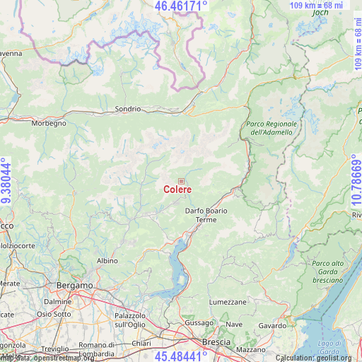
Colere GPS coordinates[2]
45° 58' 30.792" North, 10° 5' 0.816" East
| Map corner | latitude | longitude |
|---|---|---|
| Upper-left | 46.46171°, | 9.38044° |
| Center: | 45.97522°, | 10.08356° |
| Lower-right: | 45.48441°, | 10.78669° |
| Map W x H: | 108.7×108.7 km | = 67.5×67.5mi |
| max Lat: | 47.04031° ⇑8.7% North |
| Colere: | 45.97522° |
| min Lat: | ⇓91.3% South 35.50142° |
| min Long | Colere | max Long |
| 6.69888° | 10.08356° | 18.48682° |
| W 32.9%⇐ | ⇒67.1% E |
Elevation
Elevation of Colere is 1014 m = 3327 ft, and this is 707.3 m = 2321 ft above average elevation for this country.
| Max E: |
2085 m = 6841 ft | 2.9% |
| Colere | 1014 m 3327 ft | |
| Avg. | 306.7 m = 1006 ft | |
Min E: |
-4 m = -13 ft | 97.1% |
See also: Italy elevation on elevation.city.
Geographical zone
Colere is located in North temperate zone (between Tropic of Cancer and the Arctic Circle). Distance of this North polar circle is 2289.2 km =1422.4 mi to North.| Distance of | km | miles | from Colere |
|---|---|---|---|
| North Pole | 4895.1 | 3041.7 | to North |
| Arctic Circle | 2289.2 | 1422.4 | to North |
| Tropic Cancer | 2506 | 1557.2 | to South |
| Equator | 5112 | 3176.4 | to South |


Nearby cities:
15 places around Colere: (largest is in red/bold)
• Angolo Terme
10.6 km =6.6 mi,  151°
151°
• Azzone
2.3 km =1.4 mi,  79°
79°
• Bondione
8.9 km =5.5 mi,  319°
319°
• Borno
9.7 km =6 mi,  108°
108°
• Castione della Presolana
7.1 km =4.4 mi,  197°
197°
• Fino del Monte
11.5 km =7.1 mi,  217°
217°
• Gandellino
10.8 km =6.7 mi,  279°
279°
• Gromo
12.2 km =7.6 mi,  263°
263°
• Onore
10.9 km =6.8 mi,  211°
211°
• Ossimo Inferiore
12.3 km =7.6 mi, 107°
• Ossimo Superiore
11.8 km =7.3 mi, 105°
• Rovetta
12.1 km =7.5 mi, 220°
• Schilpario
6.7 km =4.2 mi,  56°
56°
• Vilminore
2.7 km =1.7 mi,  19°
19°
• Vilminore di Scalve
2.7 km =1.7 mi, 17°
Sources, notices
• [Note1] Compared only with cities in Italy existing in our database
• [Src1] Map data: © OpenStreetMap contributors (CC-BY-SA)
• [Src2] Other city data from geonames.org with taken over terms of usage.
• [Src3] Geographical zone / Annual Mean Temperature by Robert A. Rohde @ Wikipedia
