Gandellino geodata
Gandellino (Lombardy) is a seat of a third-order administrative division; located in Italy in Europe/Rome (GMT+2) time zone. With population of 464 people, there are 10040 cities with bigger population in this country. Compared to other cities in Italy, 91.8% of cities are located further ↓South; 68.3% of cities are located further →East and 88.3% of cities have lower elevation than Gandellino. Note1


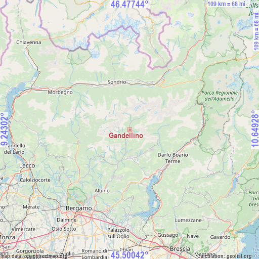
Gandellino GPS coordinates[2]
45° 59' 27.924" North, 9° 56' 46.14" East
| Map corner | latitude | longitude |
|---|---|---|
| Upper-left | 46.47744°, | 9.24302° |
| Center: | 45.99109°, | 9.94615° |
| Lower-right: | 45.50042°, | 10.64928° |
| Map W x H: | 108.6×108.6 km | = 67.5×67.5mi |
| max Lat: | 47.04031° ⇑8.2% North |
| Gandellino: | 45.99109° |
| min Lat: | ⇓91.8% South 35.50142° |
| min Long | Gandellino | max Long |
| 6.69888° | 9.94615° | 18.48682° |
| W 31.7%⇐ | ⇒68.3% E |
Elevation
Elevation of Gandellino is 677 m = 2221 ft, and this is 370.3 m = 1215 ft above average elevation for this country.
| Max E: |
2085 m = 6841 ft | 11.7% |
| Gandellino | 677 m 2221 ft | |
| Avg. | 306.7 m = 1006 ft | |
Min E: |
-4 m = -13 ft | 88.3% |
See also: Italy elevation on elevation.city.
Geographical zone
Gandellino is located in North temperate zone (between Tropic of Cancer and the Arctic Circle). Distance of this North polar circle is 2287.4 km =1421.3 mi to North.| Distance of | km | miles | from Gandellino |
|---|---|---|---|
| North Pole | 4893.3 | 3040.6 | to North |
| Arctic Circle | 2287.4 | 1421.3 | to North |
| Tropic Cancer | 2507.8 | 1558.3 | to South |
| Equator | 5113.7 | 3177.5 | to South |


Nearby cities:
15 places around Gandellino: (largest is in red/bold)
• Ardesio
6.2 km =3.9 mi,  191°
191°
• Bondione
6.9 km =4.3 mi,  44°
44°
• Castione della Presolana
12 km =7.5 mi,  135°
135°
• Clusone
11.6 km =7.2 mi,  179°
179°
• Colere
10.8 km =6.7 mi,  99°
99°
• Fino del Monte
11.6 km =7.2 mi,  161°
161°
• Gromo
3.6 km =2.2 mi,  205°
205°
• Oltressenda Alta
8.4 km =5.2 mi, 180°
• Onore
12.1 km =7.5 mi, 155°
• Piario
10.6 km =6.6 mi, 187°
• Rovetta
11.4 km =7.1 mi,  165°
165°
• Valgoglio
3.1 km =1.9 mi,  234°
234°
• Villa d'Ogna
9.7 km =6 mi, 187°
• Vilminore
11.5 km =7.1 mi,  86°
86°
• Vilminore di Scalve
11.4 km =7.1 mi, 86°
Sources, notices
• [Note1] Compared only with cities in Italy existing in our database
• [Src1] Map data: © OpenStreetMap contributors (CC-BY-SA)
• [Src2] Other city data from geonames.org with taken over terms of usage.
• [Src3] Geographical zone / Annual Mean Temperature by Robert A. Rohde @ Wikipedia
