Coazze geodata
Coazze (Piedmont) is a seat of a third-order administrative division; located in Italy in Europe/Rome (GMT+2) time zone. With population of 2,785 people, there are 3228 cities with bigger population in this country. Compared to other cities in Italy, 61.2% of cities are located further ↓South; 99% of cities are located further →East and 90.4% of cities have lower elevation than Coazze. Note1


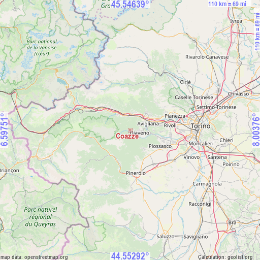
Coazze GPS coordinates[2]
45° 3' 6.516" North, 7° 18' 2.268" East
| Map corner | latitude | longitude |
|---|---|---|
| Upper-left | 45.54639°, | 6.59751° |
| Center: | 45.05181°, | 7.30063° |
| Lower-right: | 44.55292°, | 8.00376° |
| Map W x H: | 110.5×110.5 km | = 68.7×68.7mi |
| max Lat: | 47.04031° ⇑38.8% North |
| Coazze: | 45.05181° |
| min Lat: | ⇓61.2% South 35.50142° |
| min Long | Coazze | max Long |
| 6.69888° | 7.30063° | 18.48682° |
| W 1%⇐ | ⇒99% E |
Elevation
Elevation of Coazze is 729 m = 2392 ft, and this is 422.3 m = 1385 ft above average elevation for this country.
| Max E: |
2085 m = 6841 ft | 9.6% |
| Coazze | 729 m 2392 ft | |
| Avg. | 306.7 m = 1006 ft | |
Min E: |
-4 m = -13 ft | 90.4% |
See also: Italy elevation on elevation.city.
Geographical zone
Coazze is located in North temperate zone (between Tropic of Cancer and the Arctic Circle). Distance of this North polar circle is 2391.9 km =1486.3 mi to North.| Distance of | km | miles | from Coazze |
|---|---|---|---|
| North Pole | 4997.8 | 3105.5 | to North |
| Arctic Circle | 2391.9 | 1486.3 | to North |
| Tropic Cancer | 2403.4 | 1493.4 | to South |
| Equator | 5009.3 | 3112.6 | to South |


Nearby cities:
15 places around Coazze: (largest is in red/bold)
• Avigliana
8.1 km =5 mi,  67°
67°
• Baratte
8.3 km =5.2 mi,  322°
322°
• Borgone Susa
9.4 km =5.8 mi,  327°
327°
• Caprie
7.9 km =4.9 mi,  18°
18°
• Chiusa di San Michele
6.2 km =3.9 mi, 19°
• Condove
7.2 km =4.5 mi,  5°
5°
• Giaveno
3.8 km =2.4 mi,  102°
102°
• Novaretto
8.5 km =5.3 mi,  30°
30°
• Pontepietra
1.7 km =1.1 mi,  124°
124°
• San Bernardino
7.8 km =4.8 mi, 102°
• Sant'Ambrogio di Torino
7.1 km =4.4 mi,  46°
46°
• Sant'Antonino di Susa
6.6 km =4.1 mi,  340°
340°
• Vaie
5.7 km =3.5 mi,  351°
351°
• Valgioie
4.1 km =2.5 mi, 70°
• Villar Focchiardo
8.3 km =5.2 mi, 324°
Sources, notices
• [Note1] Compared only with cities in Italy existing in our database
• [Src1] Map data: © OpenStreetMap contributors (CC-BY-SA)
• [Src2] Other city data from geonames.org with taken over terms of usage.
• [Src3] Geographical zone / Annual Mean Temperature by Robert A. Rohde @ Wikipedia
