Vaie geodata
Vaie (Piedmont) is a seat of a third-order administrative division; located in Italy in Europe/Rome (GMT+2) time zone. With population of 1,450 people, there are 5245 cities with bigger population in this country. Compared to other cities in Italy, 62.4% of cities are located further ↓South; 99% of cities are located further →East and 68.9% of cities have lower elevation than Vaie. Note1


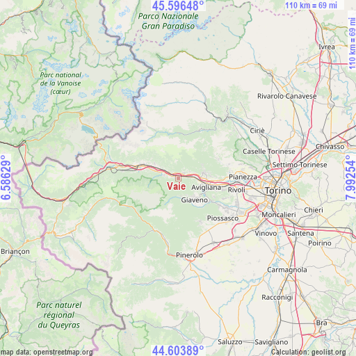
Vaie GPS coordinates[2]
45° 6' 8.424" North, 7° 17' 21.876" East
| Map corner | latitude | longitude |
|---|---|---|
| Upper-left | 45.59648°, | 6.58629° |
| Center: | 45.10234°, | 7.28941° |
| Lower-right: | 44.60389°, | 7.99254° |
| Map W x H: | 110.4×110.4 km | = 68.6×68.6mi |
| max Lat: | 47.04031° ⇑37.6% North |
| Vaie: | 45.10234° |
| min Lat: | ⇓62.4% South 35.50142° |
| min Long | Vaie | max Long |
| 6.69888° | 7.28941° | 18.48682° |
| W 1%⇐ | ⇒99% E |
Elevation
Elevation of Vaie is 383 m = 1257 ft, and this is 76.3 m = 250 ft above average elevation for this country.
| Max E: |
2085 m = 6841 ft | 31.1% |
| Vaie | 383 m 1257 ft | |
| Avg. | 306.7 m = 1006 ft | |
Min E: |
-4 m = -13 ft | 68.9% |
See also: Italy elevation on elevation.city.
Geographical zone
Vaie is located in North temperate zone (between Tropic of Cancer and the Arctic Circle). Distance of this North polar circle is 2386.3 km =1482.8 mi to North.| Distance of | km | miles | from Vaie |
|---|---|---|---|
| North Pole | 4992.2 | 3102 | to North |
| Arctic Circle | 2386.3 | 1482.8 | to North |
| Tropic Cancer | 2409 | 1496.9 | to South |
| Equator | 5014.9 | 3116.1 | to South |


Nearby cities:
15 places around Vaie: (largest is in red/bold)
• Baratte
4.3 km =2.7 mi,  283°
283°
• Borgone Susa
4.8 km =3 mi,  299°
299°
• Caprie
3.9 km =2.4 mi,  60°
60°
• Chiusa di San Michele
3 km =1.9 mi,  85°
85°
• Coazze
5.7 km =3.5 mi,  171°
171°
• Condove
2.1 km =1.3 mi,  44°
44°
• Giaveno
7.9 km =4.9 mi,  144°
144°
• Novaretto
5.5 km =3.4 mi,  71°
71°
• Pontepietra
7 km =4.3 mi,  160°
160°
• San Didero
7 km =4.3 mi, 301°
• Sant'Ambrogio di Torino
6 km =3.7 mi,  96°
96°
• Sant'Antonino di Susa
1.4 km =0.9 mi,  294°
294°
• Valgioie
6.3 km =3.9 mi,  132°
132°
• Villar Dora
7.5 km =4.7 mi,  79°
79°
• Villar Focchiardo
4.2 km =2.6 mi, 285°
Sources, notices
• [Note1] Compared only with cities in Italy existing in our database
• [Src1] Map data: © OpenStreetMap contributors (CC-BY-SA)
• [Src2] Other city data from geonames.org with taken over terms of usage.
• [Src3] Geographical zone / Annual Mean Temperature by Robert A. Rohde @ Wikipedia
