Giaveno geodata
Giaveno (Piedmont) is a seat of a third-order administrative division; located in Italy in Europe/Rome (GMT+2) time zone. With population of 11,540 people, there are 812 cities with bigger population in this country. Compared to other cities in Italy, 61% of cities are located further ↓South; 98.7% of cities are located further →East and 80.9% of cities have lower elevation than Giaveno. Note1


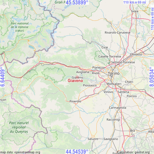
Giaveno GPS coordinates[2]
45° 2' 39.66" North, 7° 20' 49.992" East
| Map corner | latitude | longitude |
|---|---|---|
| Upper-left | 45.53899°, | 6.64409° |
| Center: | 45.04435°, | 7.34722° |
| Lower-right: | 44.54539°, | 8.05034° |
| Map W x H: | 110.5×110.5 km | = 68.7×68.7mi |
| max Lat: | 47.04031° ⇑39% North |
| Giaveno: | 45.04435° |
| min Lat: | ⇓61% South 35.50142° |
| min Long | Giaveno | max Long |
| 6.69888° | 7.34722° | 18.48682° |
| W 1.3%⇐ | ⇒98.7% E |
Elevation
Elevation of Giaveno is 538 m = 1765 ft, and this is 231.3 m = 759 ft above average elevation for this country.
| Max E: |
2085 m = 6841 ft | 19.1% |
| Giaveno | 538 m 1765 ft | |
| Avg. | 306.7 m = 1006 ft | |
Min E: |
-4 m = -13 ft | 80.9% |
See also: Italy elevation on elevation.city.
Geographical zone
Giaveno is located in North temperate zone (between Tropic of Cancer and the Arctic Circle). Distance of this North polar circle is 2392.7 km =1486.8 mi to North.| Distance of | km | miles | from Giaveno |
|---|---|---|---|
| North Pole | 4998.6 | 3106 | to North |
| Arctic Circle | 2392.7 | 1486.8 | to North |
| Tropic Cancer | 2402.5 | 1492.8 | to South |
| Equator | 5008.5 | 3112.1 | to South |


Nearby cities:
15 places around Giaveno: (largest is in red/bold)
• Avigliana
5.5 km =3.4 mi,  44°
44°
• Buttigliera Alta
7.2 km =4.5 mi,  68°
68°
• Chiusa di San Michele
6.8 km =4.2 mi,  346°
346°
• Coazze
3.8 km =2.4 mi,  282°
282°
• Cumiana
7.9 km =4.9 mi,  162°
162°
• Drubiaglio-Grangia
8 km =5 mi, 44°
• Ferriera
7.9 km =4.9 mi,  56°
56°
• Novaretto
8.2 km =5.1 mi,  4°
4°
• Pontepietra
2.2 km =1.4 mi,  266°
266°
• Reano
6.4 km =4 mi,  82°
82°
• San Bernardino
4 km =2.5 mi,  102°
102°
• Sant'Ambrogio di Torino
6 km =3.7 mi,  14°
14°
• Trana
5.8 km =3.6 mi, 96°
• Vaie
7.9 km =4.9 mi,  324°
324°
• Valgioie
2.2 km =1.4 mi, 4°
Sources, notices
• [Note1] Compared only with cities in Italy existing in our database
• [Src1] Map data: © OpenStreetMap contributors (CC-BY-SA)
• [Src2] Other city data from geonames.org with taken over terms of usage.
• [Src3] Geographical zone / Annual Mean Temperature by Robert A. Rohde @ Wikipedia
