Cimadolmo geodata
Cimadolmo (Veneto) is a seat of a third-order administrative division; located in Italy in Europe/Rome (GMT+2) time zone. With population of 1,504 people, there are 5106 cities with bigger population in this country. Compared to other cities in Italy, 85.2% of cities are located further ↓South; 60.9% of cities are located further ←West and 85.6% of cities have higher elevation than Cimadolmo. Note1


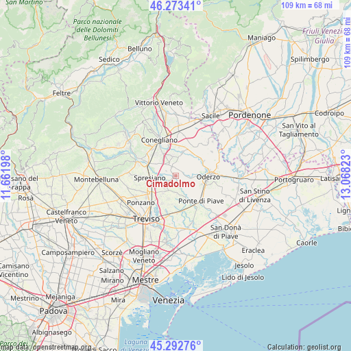
Cimadolmo GPS coordinates[2]
45° 47' 6.864" North, 12° 21' 54.36" East
| Map corner | latitude | longitude |
|---|---|---|
| Upper-left | 46.27341°, | 11.66198° |
| Center: | 45.78524°, | 12.3651° |
| Lower-right: | 45.29276°, | 13.06823° |
| Map W x H: | 109×109 km | = 67.7×67.7mi |
| max Lat: | 47.04031° ⇑14.8% North |
| Cimadolmo: | 45.78524° |
| min Lat: | ⇓85.2% South 35.50142° |
| min Long | Cimadolmo | max Long |
| 6.69888° | 12.3651° | 18.48682° |
| W 60.9%⇐ | ⇒39.1% E |
Elevation
Elevation of Cimadolmo is 29 m = 95 ft, and this is 277.7 m = 911 ft below average elevation for this country.
| Max E: |
2085 m = 6841 ft | 85.6% |
| Avg. | 306.7 m = 1006 ft | |
| Cimadolmo | 29 m = 95 ft | |
Min E: |
-4 m = -13 ft | 14.4% |
See also: Italy elevation on elevation.city.
Geographical zone
Cimadolmo is located in North temperate zone (between Tropic of Cancer and the Arctic Circle). Distance of this North polar circle is 2310.3 km =1435.6 mi to North.| Distance of | km | miles | from Cimadolmo |
|---|---|---|---|
| North Pole | 4916.2 | 3054.8 | to North |
| Arctic Circle | 2310.3 | 1435.6 | to North |
| Tropic Cancer | 2484.9 | 1544 | to South |
| Equator | 5090.8 | 3163.3 | to South |


Nearby cities:
15 places around Cimadolmo: (largest is in red/bold)
• Breda
7.5 km =4.7 mi,  200°
200°
• Candelù
5.6 km =3.5 mi,  174°
174°
• Faè
8.2 km =5.1 mi,  108°
108°
• Mareno di Piave
7.1 km =4.4 mi,  342°
342°
• Maserada sul Piave
5.2 km =3.2 mi,  224°
224°
• Negrisia
8 km =5 mi,  136°
136°
• Ormelle
4.7 km =2.9 mi,  100°
100°
• Pero
8.9 km =5.5 mi,  188°
188°
• Roncadelle
4.6 km =2.9 mi,  131°
131°
• Saletto-San Bartolomeo
7 km =4.3 mi,  160°
160°
• San Michele di Piave
1.9 km =1.2 mi,  311°
311°
• San Polo di Piave
2.2 km =1.4 mi,  77°
77°
• Spresiano
8.5 km =5.3 mi,  265°
265°
• Varago
6.8 km =4.2 mi, 218°
• Vazzola
6.5 km =4 mi,  31°
31°
Sources, notices
• [Note1] Compared only with cities in Italy existing in our database
• [Src1] Map data: © OpenStreetMap contributors (CC-BY-SA)
• [Src2] Other city data from geonames.org with taken over terms of usage.
• [Src3] Geographical zone / Annual Mean Temperature by Robert A. Rohde @ Wikipedia
