Vazzola geodata
Vazzola (Veneto) is a seat of a third-order administrative division; located in Italy in Europe/Rome (GMT+2) time zone. With population of 5,283 people, there are 1845 cities with bigger population in this country. Compared to other cities in Italy, 87.2% of cities are located further ↓South; 61.3% of cities are located further ←West and 87.8% of cities have higher elevation than Vazzola. Note1


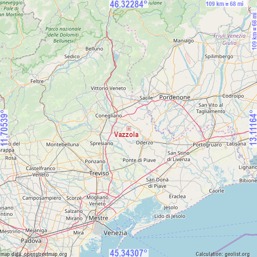
Vazzola GPS coordinates[2]
45° 50' 6.396" North, 12° 24' 30.636" East
| Map corner | latitude | longitude |
|---|---|---|
| Upper-left | 46.32284°, | 11.70539° |
| Center: | 45.83511°, | 12.40851° |
| Lower-right: | 45.34307°, | 13.11164° |
| Map W x H: | 108.9×108.9 km | = 67.7×67.7mi |
| max Lat: | 47.04031° ⇑12.8% North |
| Vazzola: | 45.83511° |
| min Lat: | ⇓87.2% South 35.50142° |
| min Long | Vazzola | max Long |
| 6.69888° | 12.40851° | 18.48682° |
| W 61.3%⇐ | ⇒38.7% E |
Elevation
Elevation of Vazzola is 23 m = 75 ft, and this is 283.7 m = 931 ft below average elevation for this country.
| Max E: |
2085 m = 6841 ft | 87.8% |
| Avg. | 306.7 m = 1006 ft | |
| Vazzola | 23 m = 75 ft | |
Min E: |
-4 m = -13 ft | 12.2% |
See also: Italy elevation on elevation.city.
Geographical zone
Vazzola is located in North temperate zone (between Tropic of Cancer and the Arctic Circle). Distance of this North polar circle is 2304.8 km =1432.1 mi to North.| Distance of | km | miles | from Vazzola |
|---|---|---|---|
| North Pole | 4910.7 | 3051.4 | to North |
| Arctic Circle | 2304.8 | 1432.1 | to North |
| Tropic Cancer | 2490.5 | 1547.5 | to South |
| Equator | 5096.4 | 3166.8 | to South |


Nearby cities:
15 places around Vazzola: (largest is in red/bold)
• Bibano
8.3 km =5.2 mi,  13°
13°
• Cimadolmo
6.5 km =4 mi,  211°
211°
• Codognè
2.8 km =1.7 mi, 6°
• Cosniga-Zoppè
6.9 km =4.3 mi,  327°
327°
• Fontanelle
4.5 km =2.8 mi,  92°
92°
• Gaiarine
7.6 km =4.7 mi,  48°
48°
• Lutrano
5.5 km =3.4 mi,  114°
114°
• Mareno di Piave
5.7 km =3.5 mi,  282°
282°
• Ormelle
6.5 km =4 mi,  169°
169°
• Roverbasso
5.6 km =3.5 mi,  40°
40°
• Saccon
6.3 km =3.9 mi,  313°
313°
• San Fior di Sotto
8 km =5 mi,  341°
341°
• San Michele di Piave
6.4 km =4 mi,  228°
228°
• San Polo di Piave
5.2 km =3.2 mi,  193°
193°
• San Vendemiano
7.3 km =4.5 mi,  322°
322°
Sources, notices
• [Note1] Compared only with cities in Italy existing in our database
• [Src1] Map data: © OpenStreetMap contributors (CC-BY-SA)
• [Src2] Other city data from geonames.org with taken over terms of usage.
• [Src3] Geographical zone / Annual Mean Temperature by Robert A. Rohde @ Wikipedia
