Roncadelle geodata
Roncadelle (Veneto) is a populated place; located in Italy in Europe/Rome (GMT+2) time zone. With population of 858 people, there are 7366 cities with bigger population in this country. Compared to other cities in Italy, 83.9% of cities are located further ↓South; 61.4% of cities are located further ←West and 91.1% of cities have higher elevation than Roncadelle. Note1


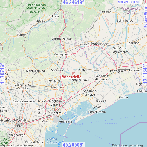
Roncadelle GPS coordinates[2]
45° 45' 28.008" North, 12° 24' 37.008" East
| Map corner | latitude | longitude |
|---|---|---|
| Upper-left | 46.24619°, | 11.70716° |
| Center: | 45.75778°, | 12.41028° |
| Lower-right: | 45.26506°, | 13.11341° |
| Map W x H: | 109.1×109.1 km | = 67.8×67.8mi |
| max Lat: | 47.04031° ⇑16.1% North |
| Roncadelle: | 45.75778° |
| min Lat: | ⇓83.9% South 35.50142° |
| min Long | Roncadelle | max Long |
| 6.69888° | 12.41028° | 18.48682° |
| W 61.4%⇐ | ⇒38.6% E |
Elevation
Elevation of Roncadelle is 16 m = 52 ft, and this is 290.7 m = 954 ft below average elevation for this country.
| Max E: |
2085 m = 6841 ft | 91.1% |
| Avg. | 306.7 m = 1006 ft | |
| Roncadelle | 16 m = 52 ft | |
Min E: |
-4 m = -13 ft | 8.9% |
See also: Italy elevation on elevation.city.
Geographical zone
Roncadelle is located in North temperate zone (between Tropic of Cancer and the Arctic Circle). Distance of this North polar circle is 2313.4 km =1437.5 mi to North.| Distance of | km | miles | from Roncadelle |
|---|---|---|---|
| North Pole | 4919.3 | 3056.7 | to North |
| Arctic Circle | 2313.4 | 1437.5 | to North |
| Tropic Cancer | 2481.9 | 1542.2 | to South |
| Equator | 5087.8 | 3161.4 | to South |


Nearby cities:
15 places around Roncadelle: (largest is in red/bold)
• Bocca Callalta
6.4 km =4 mi,  156°
156°
• Candelù
3.9 km =2.4 mi,  229°
229°
• Cavrie
6.8 km =4.2 mi,  207°
207°
• Cimadolmo
4.6 km =2.9 mi,  311°
311°
• Fagarè
5.8 km =3.6 mi,  166°
166°
• Faè
4.3 km =2.7 mi,  83°
83°
• Levada
5.4 km =3.4 mi,  118°
118°
• Negrisia
3.3 km =2.1 mi,  143°
143°
• Oderzo
7 km =4.3 mi,  68°
68°
• Ormelle
2.5 km =1.6 mi,  26°
26°
• Ponte di Piave
5.9 km =3.7 mi, 137°
• Saletto-San Bartolomeo
3.7 km =2.3 mi,  198°
198°
• San Michele di Piave
6.6 km =4.1 mi, 311°
• San Polo di Piave
3.8 km =2.4 mi,  339°
339°
• Vigonovo di Sopra
6.6 km =4.1 mi,  133°
133°
Sources, notices
• [Note1] Compared only with cities in Italy existing in our database
• [Src1] Map data: © OpenStreetMap contributors (CC-BY-SA)
• [Src2] Other city data from geonames.org with taken over terms of usage.
• [Src3] Geographical zone / Annual Mean Temperature by Robert A. Rohde @ Wikipedia
