Chiusi della Verna geodata
Chiusi della Verna (Tuscany) is a seat of a third-order administrative division; located in Italy in Europe/Rome (GMT+2) time zone. With population of 485 people, there are 9975 cities with bigger population in this country. Compared to other cities in Italy, 58.1% of cities are located further ↑North; 55% of cities are located further ←West and 95.9% of cities have lower elevation than Chiusi della Verna. Note1
Administrative division(s):
- Level 1: Tuscany
- Level 2: Province of Arezzo
- Level 3: Chiusi della Verna


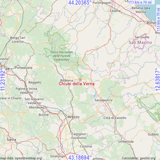
Chiusi della Verna GPS coordinates[2]
43° 41' 50.82" North, 11° 56' 6.144" East
| Map corner | latitude | longitude |
|---|---|---|
| Upper-left | 44.20365°, | 11.23192° |
| Center: | 43.69745°, | 11.93504° |
| Lower-right: | 43.18694°, | 12.63817° |
| Map W x H: | 113×113 km | = 70.2×70.2mi |
| max Lat: | 47.04031° ⇑58.1% North |
| Chiusi della Verna: | 43.69745° |
| min Lat: | ⇓41.9% South 35.50142° |
| min Long | Chiusi della Ve | max Long |
| 6.69888° | 11.93504° | 18.48682° |
| W 55%⇐ | ⇒45% E |
Elevation
Elevation of Chiusi della Verna is 930 m = 3051 ft, and this is 623.3 m = 2045 ft above average elevation for this country.
| Max E: |
2085 m = 6841 ft | 4.1% |
| Chiusi della Verna | 930 m 3051 ft | |
| Avg. | 306.7 m = 1006 ft | |
Min E: |
-4 m = -13 ft | 95.9% |
See also: Italy elevation on elevation.city.
Geographical zone
Chiusi della Verna is located in North temperate zone (between Tropic of Cancer and the Arctic Circle). Distance of this Northern Tropic circle is 2252.8 km =1399.8 mi to South.| Distance of | km | miles | from Chiusi della Verna |
|---|---|---|---|
| North Pole | 5148.4 | 3199.1 | to North |
| Arctic Circle | 2542.5 | 1579.8 | to North |
| Tropic Cancer | 2252.8 | 1399.8 | to South |
| Equator | 4858.7 | 3019.1 | to South |


Nearby cities:
15 places around Chiusi della Verna: (largest is in red/bold)
• Badia Prataglia
11.7 km =7.3 mi,  337°
337°
• Bagno di Romagna
15.5 km =9.6 mi,  7°
7°
• Bibbiena
9.7 km =6 mi,  270°
270°
• Capolona
15.6 km =9.7 mi,  201°
201°
• Caprese Michelangelo
7.5 km =4.7 mi,  147°
147°
• Chitignano
5.9 km =3.7 mi,  227°
227°
• Ortignano Raggiolo
15.1 km =9.4 mi,  262°
262°
• Partina
10.8 km =6.7 mi,  302°
302°
• Pieve Santo Stefano
9 km =5.6 mi,  108°
108°
• Ponte a Poppi
14.1 km =8.8 mi,  285°
285°
• Poppi
13.8 km =8.6 mi,  281°
281°
• Rassina
9.7 km =6 mi, 234°
• Soci
10.5 km =6.5 mi, 288°
• Subbiano
14.2 km =8.8 mi, 201°
• Verghereto
12.2 km =7.6 mi,  27°
27°
Sources, notices
• [Note1] Compared only with cities in Italy existing in our database
• [Src1] Map data: © OpenStreetMap contributors (CC-BY-SA)
• [Src2] Other city data from geonames.org with taken over terms of usage.
• [Src3] Geographical zone / Annual Mean Temperature by Robert A. Rohde @ Wikipedia
