Verghereto geodata
Verghereto (Emilia-Romagna) is a seat of a third-order administrative division; located in Italy in Europe/Rome (GMT+2) time zone. With population of 220 people, there are 11032 cities with bigger population in this country. Compared to other cities in Italy, 57% of cities are located further ↑North; 55.9% of cities are located further ←West and 93.5% of cities have lower elevation than Verghereto. Note1
Administrative division(s):
- Level 1: Emilia-Romagna
- Level 2: Provincia di Forlì-Cesena
- Level 3: Verghereto


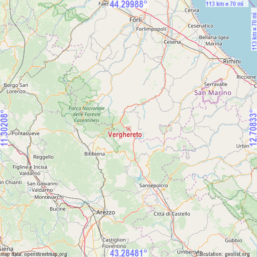
Verghereto GPS coordinates[2]
43° 47' 40.2" North, 12° 0' 18.72" East
| Map corner | latitude | longitude |
|---|---|---|
| Upper-left | 44.29988°, | 11.30208° |
| Center: | 43.7945°, | 12.0052° |
| Lower-right: | 43.28481°, | 12.70833° |
| Map W x H: | 112.9×112.9 km | = 70.2×70.2mi |
| max Lat: | 47.04031° ⇑57% North |
| Verghereto: | 43.7945° |
| min Lat: | ⇓43% South 35.50142° |
| min Long | Verghereto | max Long |
| 6.69888° | 12.0052° | 18.48682° |
| W 55.9%⇐ | ⇒44.1% E |
Elevation
Elevation of Verghereto is 815 m = 2674 ft, and this is 508.3 m = 1668 ft above average elevation for this country.
| Max E: |
2085 m = 6841 ft | 6.5% |
| Verghereto | 815 m 2674 ft | |
| Avg. | 306.7 m = 1006 ft | |
Min E: |
-4 m = -13 ft | 93.5% |
See also: Italy elevation on elevation.city.
Geographical zone
Verghereto is located in North temperate zone (between Tropic of Cancer and the Arctic Circle). Distance of this Northern Tropic circle is 2263.6 km =1406.5 mi to South.| Distance of | km | miles | from Verghereto |
|---|---|---|---|
| North Pole | 5137.6 | 3192.4 | to North |
| Arctic Circle | 2531.7 | 1573.1 | to North |
| Tropic Cancer | 2263.6 | 1406.5 | to South |
| Equator | 4869.5 | 3025.8 | to South |


Nearby cities:
15 places around Verghereto: (largest is in red/bold)
• Alfero
7.1 km =4.4 mi,  34°
34°
• Badia Prataglia
10.2 km =6.3 mi,  269°
269°
• Badia Tedalda
17.2 km =10.7 mi,  123°
123°
• Bagno di Romagna
5.8 km =3.6 mi,  321°
321°
• Bibbiena
18.6 km =11.6 mi,  235°
235°
• Caprese Michelangelo
17.2 km =10.7 mi,  185°
185°
• Casteldelci
12 km =7.5 mi,  91°
91°
• Chitignano
17.8 km =11.1 mi,  213°
213°
• Chiusi della Verna
12.2 km =7.6 mi, 207°
• Partina
15.6 km =9.7 mi,  251°
251°
• Pieve Santo Stefano
14 km =8.7 mi,  168°
168°
• San Piero in Bagno
7.4 km =4.6 mi,  342°
342°
• Sant'Agata Feltria
17.9 km =11.1 mi,  64°
64°
• Sarsina
17.8 km =11.1 mi,  38°
38°
• Soci
17.3 km =10.7 mi, 244°
Sources, notices
• [Note1] Compared only with cities in Italy existing in our database
• [Src1] Map data: © OpenStreetMap contributors (CC-BY-SA)
• [Src2] Other city data from geonames.org with taken over terms of usage.
• [Src3] Geographical zone / Annual Mean Temperature by Robert A. Rohde @ Wikipedia
