Partina geodata
Partina (Tuscany) is a populated place; located in Italy in Europe/Rome (GMT+2) time zone. With population of 558 people, there are 9366 cities with bigger population in this country. Compared to other cities in Italy, 57.5% of cities are located further ↑North; 53.4% of cities are located further ←West and 73.5% of cities have lower elevation than Partina. Note1


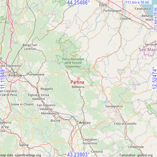
Partina GPS coordinates[2]
43° 44' 56.76" North, 11° 49' 17.796" East
| Map corner | latitude | longitude |
|---|---|---|
| Upper-left | 44.25486°, | 11.11849° |
| Center: | 43.7491°, | 11.82161° |
| Lower-right: | 43.23903°, | 12.52474° |
| Map W x H: | 112.9×112.9 km | = 70.2×70.2mi |
| max Lat: | 47.04031° ⇑57.5% North |
| Partina: | 43.7491° |
| min Lat: | ⇓42.5% South 35.50142° |
| min Long | Partina | max Long |
| 6.69888° | 11.82161° | 18.48682° |
| W 53.4%⇐ | ⇒46.6% E |
Elevation
Elevation of Partina is 431 m = 1414 ft, and this is 124.3 m = 408 ft above average elevation for this country.
| Max E: |
2085 m = 6841 ft | 26.5% |
| Partina | 431 m 1414 ft | |
| Avg. | 306.7 m = 1006 ft | |
Min E: |
-4 m = -13 ft | 73.5% |
See also: Italy elevation on elevation.city.
Geographical zone
Partina is located in North temperate zone (between Tropic of Cancer and the Arctic Circle). Distance of this Northern Tropic circle is 2258.5 km =1403.4 mi to South.| Distance of | km | miles | from Partina |
|---|---|---|---|
| North Pole | 5142.6 | 3195.5 | to North |
| Arctic Circle | 2536.7 | 1576.2 | to North |
| Tropic Cancer | 2258.5 | 1403.4 | to South |
| Equator | 4864.4 | 3022.6 | to South |


Nearby cities:
15 places around Partina: (largest is in red/bold)
• Badia Prataglia
6.8 km =4.2 mi,  42°
42°
• Bagno di Romagna
14.7 km =9.1 mi,  49°
49°
• Bibbiena
5.6 km =3.5 mi,  185°
185°
• Castel San Niccolò
9 km =5.6 mi,  266°
266°
• Chitignano
10.8 km =6.7 mi,  153°
153°
• Chiusi della Verna
10.8 km =6.7 mi,  122°
122°
• Ortignano Raggiolo
9.7 km =6 mi,  217°
217°
• Ponte a Poppi
4.8 km =3 mi,  246°
246°
• Poppi
5.4 km =3.4 mi,  235°
235°
• Pratovecchio
8.9 km =5.5 mi,  298°
298°
• Rassina
11.4 km =7.1 mi,  174°
174°
• Soci
2.5 km =1.6 mi,  200°
200°
• Stia
10.6 km =6.6 mi, 301°
• Strada
9 km =5.6 mi, 266°
• Verghereto
15.6 km =9.7 mi,  71°
71°
Sources, notices
• [Note1] Compared only with cities in Italy existing in our database
• [Src1] Map data: © OpenStreetMap contributors (CC-BY-SA)
• [Src2] Other city data from geonames.org with taken over terms of usage.
• [Src3] Geographical zone / Annual Mean Temperature by Robert A. Rohde @ Wikipedia
