Giustenice geodata
Giustenice (Liguria) is a seat of a third-order administrative division; located in Italy in Europe/Rome (GMT+2) time zone. With population of 895 people, there are 7179 cities with bigger population in this country. Compared to other cities in Italy, 53% of cities are located further ↑North; 90.7% of cities are located further →East and 58.1% of cities have higher elevation than Giustenice. Note1


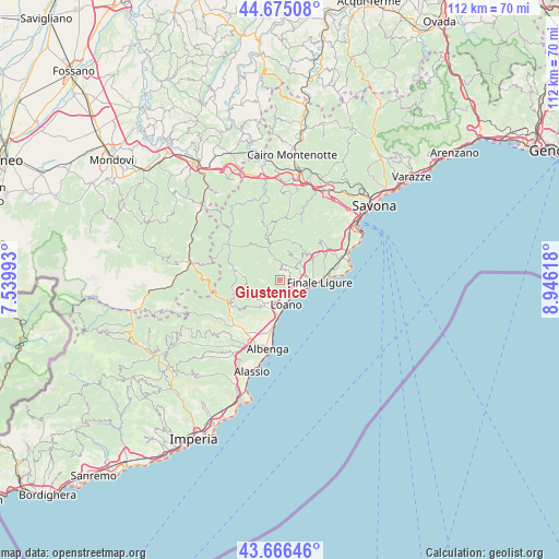
Giustenice GPS coordinates[2]
44° 10' 22.548" North, 8° 14' 34.98" East
| Map corner | latitude | longitude |
|---|---|---|
| Upper-left | 44.67508°, | 7.53993° |
| Center: | 44.17293°, | 8.24305° |
| Lower-right: | 43.66646°, | 8.94618° |
| Map W x H: | 112.1×112.1 km | = 69.7×69.7mi |
| max Lat: | 47.04031° ⇑53% North |
| Giustenice: | 44.17293° |
| min Lat: | ⇓47% South 35.50142° |
| min Long | Giustenice | max Long |
| 6.69888° | 8.24305° | 18.48682° |
| W 9.3%⇐ | ⇒90.7% E |
Elevation
Elevation of Giustenice is 179 m = 587 ft, and this is 127.7 m = 419 ft below average elevation for this country.
| Max E: |
2085 m = 6841 ft | 58.1% |
| Avg. | 306.7 m = 1006 ft | |
| Giustenice | 179 m = 587 ft | |
Min E: |
-4 m = -13 ft | 41.9% |
See also: Italy elevation on elevation.city.
Geographical zone
Giustenice is located in North temperate zone (between Tropic of Cancer and the Arctic Circle). Distance of this Northern Tropic circle is 2305.7 km =1432.7 mi to South.| Distance of | km | miles | from Giustenice |
|---|---|---|---|
| North Pole | 5095.5 | 3166.2 | to North |
| Arctic Circle | 2489.6 | 1547 | to North |
| Tropic Cancer | 2305.7 | 1432.7 | to South |
| Equator | 4911.6 | 3051.9 | to South |


Nearby cities:
15 places around Giustenice: (largest is in red/bold)
• Balestrino
7.9 km =4.9 mi,  226°
226°
• Boissano
4.5 km =2.8 mi,  202°
202°
• Borghetto Santo Spirito
6.8 km =4.2 mi,  181°
181°
• Borgio
5.4 km =3.4 mi,  106°
106°
• Calice Ligure
5.5 km =3.4 mi,  49°
49°
• Feglino
8.2 km =5.1 mi, 51°
• Finale Ligure
8 km =5 mi,  92°
92°
• Gorra
4.5 km =2.8 mi,  76°
76°
• Loano
5.2 km =3.2 mi,  167°
167°
• Magliolo
2.2 km =1.4 mi,  12°
12°
• Pietra Ligure
4.1 km =2.5 mi,  130°
130°
• Rialto
6.1 km =3.8 mi, 13°
• San Lorenzo
0.1 km =0.1 mi, 83°
• Toirano
5.8 km =3.6 mi,  209°
209°
• Tovo San Giacomo
2.2 km =1.4 mi, 81°
Sources, notices
• [Note1] Compared only with cities in Italy existing in our database
• [Src1] Map data: © OpenStreetMap contributors (CC-BY-SA)
• [Src2] Other city data from geonames.org with taken over terms of usage.
• [Src3] Geographical zone / Annual Mean Temperature by Robert A. Rohde @ Wikipedia
