Albenga geodata
Albenga (Liguria) is a seat of a third-order administrative division; located in Italy in Europe/Rome (GMT+2) time zone. With population of 17,103 people, there are 522 cities with bigger population in this country. Compared to other cities in Italy, 54.2% of cities are located further ↑North; 90.9% of cities are located further →East and 97.8% of cities have higher elevation than Albenga. Note1


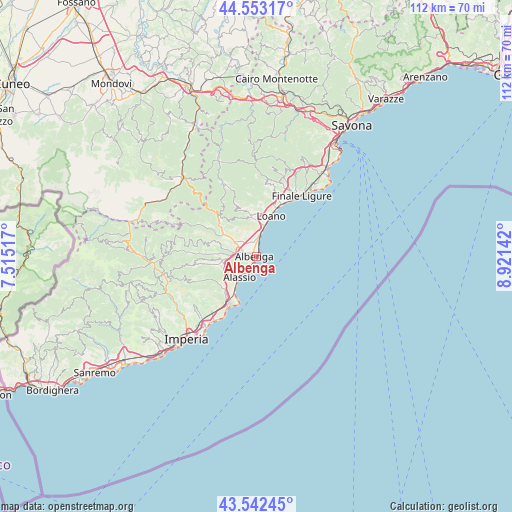
Albenga GPS coordinates[2]
44° 2' 59.892" North, 8° 13' 5.844" East
| Map corner | latitude | longitude |
|---|---|---|
| Upper-left | 44.55317°, | 7.51517° |
| Center: | 44.04997°, | 8.21829° |
| Lower-right: | 43.54245°, | 8.92142° |
| Map W x H: | 112.4×112.4 km | = 69.8×69.8mi |
| max Lat: | 47.04031° ⇑54.2% North |
| Albenga: | 44.04997° |
| min Lat: | ⇓45.8% South 35.50142° |
| min Long | Albenga | max Long |
| 6.69888° | 8.21829° | 18.48682° |
| W 9.1%⇐ | ⇒90.9% E |
Elevation
Elevation of Albenga is 4 m = 13 ft, and this is 302.7 m = 993 ft below average elevation for this country.
| Max E: |
2085 m = 6841 ft | 97.8% |
| Avg. | 306.7 m = 1006 ft | |
| Albenga | 4 m = 13 ft | |
Min E: |
-4 m = -13 ft | 2.2% |
See also: Italy elevation on elevation.city.
Geographical zone
Albenga is located in North temperate zone (between Tropic of Cancer and the Arctic Circle). Distance of this Northern Tropic circle is 2292 km =1424.2 mi to South.| Distance of | km | miles | from Albenga |
|---|---|---|---|
| North Pole | 5109.2 | 3174.7 | to North |
| Arctic Circle | 2503.3 | 1555.5 | to North |
| Tropic Cancer | 2292 | 1424.2 | to South |
| Equator | 4897.9 | 3043.4 | to South |


Nearby cities:
15 places around Albenga: (largest is in red/bold)
• Alassio
6.6 km =4.1 mi,  218°
218°
• Arnasco
9.4 km =5.8 mi,  289°
289°
• Balestrino
9.1 km =5.7 mi,  335°
335°
• Bastia
3.8 km =2.4 mi,  283°
283°
• Borghetto Santo Spirito
7.1 km =4.4 mi,  14°
14°
• Campochiesa
2.9 km =1.8 mi,  323°
323°
• Ceriale
4.7 km =2.9 mi, 10°
• Chiesa
9.3 km =5.8 mi, 289°
• Cisano
6.9 km =4.3 mi,  305°
305°
• Laigueglia
9.5 km =5.9 mi,  210°
210°
• Loano
9.2 km =5.7 mi,  19°
19°
• San Fedele-Lusignano
3 km =1.9 mi,  260°
260°
• Toirano
8.6 km =5.3 mi,  354°
354°
• Villafranca
9.2 km =5.7 mi, 258°
• Villanova d'Albenga
6 km =3.7 mi,  267°
267°
Sources, notices
• [Note1] Compared only with cities in Italy existing in our database
• [Src1] Map data: © OpenStreetMap contributors (CC-BY-SA)
• [Src2] Other city data from geonames.org with taken over terms of usage.
• [Src3] Geographical zone / Annual Mean Temperature by Robert A. Rohde @ Wikipedia
