Mirandola geodata
Mirandola (Emilia-Romagna) is a seat of a third-order administrative division; located in Italy in Europe/Rome (GMT+2) time zone. With population of 17,380 people, there are 508 cities with bigger population in this country. Compared to other cities in Italy, 57.7% of cities are located further ↓South; 56.4% of cities are located further →East and 89% of cities have higher elevation than Mirandola. Note1


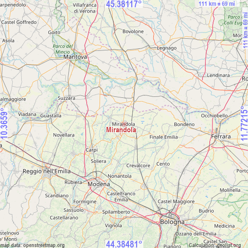
Mirandola GPS coordinates[2]
44° 53' 6.54" North, 11° 4' 8.472" East
| Map corner | latitude | longitude |
|---|---|---|
| Upper-left | 45.38117°, | 10.3659° |
| Center: | 44.88515°, | 11.06902° |
| Lower-right: | 44.38481°, | 11.77215° |
| Map W x H: | 110.8×110.8 km | = 68.8×68.8mi |
| max Lat: | 47.04031° ⇑42.3% North |
| Mirandola: | 44.88515° |
| min Lat: | ⇓57.7% South 35.50142° |
| min Long | Mirandola | max Long |
| 6.69888° | 11.06902° | 18.48682° |
| W 43.6%⇐ | ⇒56.4% E |
Elevation
Elevation of Mirandola is 20 m = 66 ft, and this is 286.7 m = 941 ft below average elevation for this country.
| Max E: |
2085 m = 6841 ft | 89% |
| Avg. | 306.7 m = 1006 ft | |
| Mirandola | 20 m = 66 ft | |
Min E: |
-4 m = -13 ft | 11% |
See also: Italy elevation on elevation.city.
Geographical zone
Mirandola is located in North temperate zone (between Tropic of Cancer and the Arctic Circle). Distance of this Northern Tropic circle is 2384.8 km =1481.8 mi to South.| Distance of | km | miles | from Mirandola |
|---|---|---|---|
| North Pole | 5016.3 | 3117 | to North |
| Arctic Circle | 2410.4 | 1497.8 | to North |
| Tropic Cancer | 2384.8 | 1481.8 | to South |
| Equator | 4990.8 | 3101.1 | to South |


Nearby cities:
15 places around Mirandola: (largest is in red/bold)
• Cavezzo
6.4 km =4 mi,  209°
209°
• Concordia sulla Secchia
7.1 km =4.4 mi,  295°
295°
• Fossa
5.5 km =3.4 mi,  319°
319°
• Medolla
4.3 km =2.7 mi,  181°
181°
• Poggio Rusco
9.5 km =5.9 mi,  16°
16°
• Quarantoli
4.7 km =2.9 mi,  35°
35°
• Rivara
9.3 km =5.8 mi,  122°
122°
• Rovereto
10.9 km =6.8 mi,  238°
238°
• San Biagio
5 km =3.1 mi, 122°
• San Felice sul Panaro
7.6 km =4.7 mi,  134°
134°
• San Giacomo delle Segnate
10.3 km =6.4 mi,  344°
344°
• San Giovanni del Dosso
9.1 km =5.7 mi,  6°
6°
• San Possidonio
7.1 km =4.4 mi,  259°
259°
• Vallalta
8.1 km =5 mi, 322°
• Villa Motta
8.7 km =5.4 mi,  220°
220°
Sources, notices
• [Note1] Compared only with cities in Italy existing in our database
• [Src1] Map data: © OpenStreetMap contributors (CC-BY-SA)
• [Src2] Other city data from geonames.org with taken over terms of usage.
• [Src3] Geographical zone / Annual Mean Temperature by Robert A. Rohde @ Wikipedia
