Offida geodata
Offida (The Marches) is a seat of a third-order administrative division; located in Italy in Europe/Rome (GMT+2) time zone. With population of 2,798 people, there are 3219 cities with bigger population in this country. Compared to other cities in Italy, 63.7% of cities are located further ↑North; 75.6% of cities are located further ←West and 56.5% of cities have lower elevation than Offida. Note1
Administrative division(s):
- Level 1: The Marches
- Level 2: Provincia di Ascoli Piceno
- Level 3: Offida


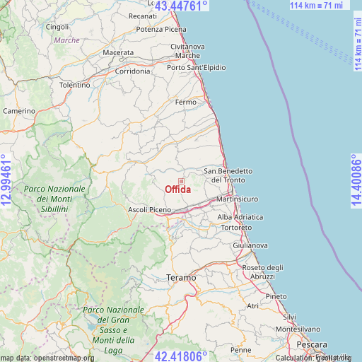
Offida GPS coordinates[2]
42° 56' 5.964" North, 13° 41' 51.828" East
| Map corner | latitude | longitude |
|---|---|---|
| Upper-left | 43.44761°, | 12.99461° |
| Center: | 42.93499°, | 13.69773° |
| Lower-right: | 42.41806°, | 14.40086° |
| Map W x H: | 114.5×114.5 km | = 71.1×71.1mi |
| max Lat: | 47.04031° ⇑63.7% North |
| Offida: | 42.93499° |
| min Lat: | ⇓36.3% South 35.50142° |
| min Long | Offida | max Long |
| 6.69888° | 13.69773° | 18.48682° |
| W 75.6%⇐ | ⇒24.4% E |
Elevation
Elevation of Offida is 275 m = 902 ft, and this is 31.7 m = 104 ft below average elevation for this country.
| Max E: |
2085 m = 6841 ft | 43.5% |
| Avg. | 306.7 m = 1006 ft | |
| Offida | 275 m = 902 ft | |
Min E: |
-4 m = -13 ft | 56.5% |
See also: Italy elevation on elevation.city.
Geographical zone
Offida is located in North temperate zone (between Tropic of Cancer and the Arctic Circle). Distance of this Northern Tropic circle is 2168 km =1347.1 mi to South.| Distance of | km | miles | from Offida |
|---|---|---|---|
| North Pole | 5233.1 | 3251.7 | to North |
| Arctic Circle | 2627.3 | 1632.5 | to North |
| Tropic Cancer | 2168 | 1347.1 | to South |
| Equator | 4773.9 | 2966.4 | to South |


Nearby cities:
15 places around Offida: (largest is in red/bold)
• Appignano del Tronto
5 km =3.1 mi,  215°
215°
• Campolungo-Villa Sant'Antonio
9.5 km =5.9 mi,  187°
187°
• Castel di Lama
8 km =5 mi,  167°
167°
• Castignano
5.9 km =3.7 mi,  274°
274°
• Castorano
4.9 km =3 mi,  147°
147°
• Colli del Tronto
7.6 km =4.7 mi, 147°
• Cossignano
5.4 km =3.4 mi,  353°
353°
• Monsampolo del Tronto
8.8 km =5.5 mi,  118°
118°
• Pagliare
9.4 km =5.8 mi,  141°
141°
• Piattoni-Villa Sant'Antonio
7.7 km =4.8 mi, 171°
• Ripaberarda
7.8 km =4.8 mi,  257°
257°
• Ripatransone
8.9 km =5.5 mi,  35°
35°
• San Silvestro
7.9 km =4.9 mi,  161°
161°
• Spinetoli
7.4 km =4.6 mi,  132°
132°
• Villa San Giuseppe
8.3 km =5.2 mi, 152°
Sources, notices
• [Note1] Compared only with cities in Italy existing in our database
• [Src1] Map data: © OpenStreetMap contributors (CC-BY-SA)
• [Src2] Other city data from geonames.org with taken over terms of usage.
• [Src3] Geographical zone / Annual Mean Temperature by Robert A. Rohde @ Wikipedia
