Castelrotto geodata
Castelrotto (Trentino-Alto Adige) is a seat of a third-order administrative division; located in Italy in Europe/Rome (GMT+2) time zone. With population of 1,545 people, there are 5022 cities with bigger population in this country. Compared to other cities in Italy, 98.7% of cities are located further ↓South; 50.2% of cities are located further ←West and 97.8% of cities have lower elevation than Castelrotto. Note1


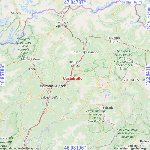
Castelrotto GPS coordinates[2]
46° 33' 59.832" North, 11° 33' 39.528" East
| Map corner | latitude | longitude |
|---|---|---|
| Upper-left | 47.04787°, | 10.85786° |
| Center: | 46.56662°, | 11.56098° |
| Lower-right: | 46.08106°, | 12.26411° |
| Map W x H: | 107.5×107.5 km | = 66.8×66.8mi |
| max Lat: | 47.04031° ⇑1.3% North |
| Castelrotto: | 46.56662° |
| min Lat: | ⇓98.7% South 35.50142° |
| min Long | Castelrotto | max Long |
| 6.69888° | 11.56098° | 18.48682° |
| W 50.2%⇐ | ⇒49.8% E |
Elevation
Elevation of Castelrotto is 1070 m = 3510 ft, and this is 763.3 m = 2504 ft above average elevation for this country.
| Max E: |
2085 m = 6841 ft | 2.2% |
| Castelrotto | 1070 m 3510 ft | |
| Avg. | 306.7 m = 1006 ft | |
Min E: |
-4 m = -13 ft | 97.8% |
See also: Italy elevation on elevation.city.
Geographical zone
Castelrotto is located in North temperate zone (between Tropic of Cancer and the Arctic Circle). Distance of this North polar circle is 2223.5 km =1381.6 mi to North.| Distance of | km | miles | from Castelrotto |
|---|---|---|---|
| North Pole | 4829.3 | 3000.8 | to North |
| Arctic Circle | 2223.5 | 1381.6 | to North |
| Tropic Cancer | 2571.8 | 1598 | to South |
| Equator | 5177.7 | 3217.3 | to South |


Nearby cities:
15 places around Castelrotto: (largest is in red/bold)
• Auna di Sotto
11 km =6.8 mi,  236°
236°
• Barbiano
5.2 km =3.2 mi,  323°
323°
• Barbiano - Barbian
5.1 km =3.2 mi, 323°
• Chiusa
8.2 km =5.1 mi,  2°
2°
• Collalbo
8.3 km =5.2 mi,  249°
249°
• Fiè Allo Sciliar
7.2 km =4.5 mi,  219°
219°
• Laion
4.6 km =2.9 mi, 4°
• Ortisei
8.5 km =5.3 mi,  82°
82°
• Ponte Gardena
4.1 km =2.5 mi,  325°
325°
• Renon - Ritten
8.4 km =5.2 mi, 250°
• Siusi
2.8 km =1.7 mi,  183°
183°
• Tires
11.3 km =7 mi,  193°
193°
• Velturno
11.5 km =7.1 mi,  13°
13°
• Villandro
7.4 km =4.6 mi,  346°
346°
• Villandro - Villanders
7.4 km =4.6 mi, 345°
Sources, notices
• [Note1] Compared only with cities in Italy existing in our database
• [Src1] Map data: © OpenStreetMap contributors (CC-BY-SA)
• [Src2] Other city data from geonames.org with taken over terms of usage.
• [Src3] Geographical zone / Annual Mean Temperature by Robert A. Rohde @ Wikipedia
