Ortisei geodata
Ortisei (Trentino-Alto Adige) is a seat of a third-order administrative division; located in Italy in Europe/Rome (GMT+2) time zone. With population of 4,306 people, there are 2235 cities with bigger population in this country. Compared to other cities in Italy, 98.8% of cities are located further ↓South; 51.4% of cities are located further ←West and 98.9% of cities have lower elevation than Ortisei. Note1
Administrative division(s):
- Level 1: Trentino-Alto Adige
- Level 2: Bolzano
- Level 3: Ortisei - St. Ulrich


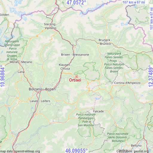
Ortisei GPS coordinates[2]
46° 34' 33.708" North, 11° 40' 18.336" East
| Map corner | latitude | longitude |
|---|---|---|
| Upper-left | 47.0572°, | 10.96864° |
| Center: | 46.57603°, | 11.67176° |
| Lower-right: | 46.09055°, | 12.37489° |
| Map W x H: | 107.5×107.5 km | = 66.8×66.8mi |
| max Lat: | 47.04031° ⇑1.2% North |
| Ortisei: | 46.57603° |
| min Lat: | ⇓98.8% South 35.50142° |
| min Long | Ortisei | max Long |
| 6.69888° | 11.67176° | 18.48682° |
| W 51.4%⇐ | ⇒48.6% E |
Elevation
Elevation of Ortisei is 1238 m = 4062 ft, and this is 931.3 m = 3055 ft above average elevation for this country.
| Max E: |
2085 m = 6841 ft | 1.1% |
| Ortisei | 1238 m 4062 ft | |
| Avg. | 306.7 m = 1006 ft | |
Min E: |
-4 m = -13 ft | 98.9% |
See also: Italy elevation on elevation.city.
Geographical zone
Ortisei is located in North temperate zone (between Tropic of Cancer and the Arctic Circle). Distance of this North polar circle is 2222.4 km =1380.9 mi to North.| Distance of | km | miles | from Ortisei |
|---|---|---|---|
| North Pole | 4828.3 | 3000.2 | to North |
| Arctic Circle | 2222.4 | 1380.9 | to North |
| Tropic Cancer | 2572.9 | 1598.7 | to South |
| Equator | 5178.8 | 3218 | to South |


Nearby cities:
15 places around Ortisei: (largest is in red/bold)
• Albes
11.6 km =7.2 mi,  344°
344°
• Barbiano
11.9 km =7.4 mi,  285°
285°
• Barbiano - Barbian
11.9 km =7.4 mi,  284°
284°
• Castelrotto
8.5 km =5.3 mi,  262°
262°
• Chiusa
10.8 km =6.7 mi,  311°
311°
• Funes - Villnoess
7.4 km =4.6 mi,  3°
3°
• Laion
8.9 km =5.5 mi, 293°
• Ponte Gardena
11 km =6.8 mi, 282°
• San Pietro
7.3 km =4.5 mi,  6°
6°
• Santa Cristina Valgardena
4.8 km =3 mi,  107°
107°
• Selva
7.2 km =4.5 mi, 109°
• Siusi
9.5 km =5.9 mi,  245°
245°
• Velturno
11.6 km =7.2 mi,  330°
330°
• Villandro
11.9 km =7.4 mi,  300°
300°
• Villandro - Villanders
12 km =7.5 mi, 300°
In other languages:
- In German: St. Ulrich in Gröden, St. Ulrich im Grödnertal
- In Russian: Ортизеи
- In Chinese: 奥尔蒂塞伊
Sources, notices
• [Note1] Compared only with cities in Italy existing in our database
• [Src1] Map data: © OpenStreetMap contributors (CC-BY-SA)
• [Src2] Other city data from geonames.org with taken over terms of usage.
• [Src3] Geographical zone / Annual Mean Temperature by Robert A. Rohde @ Wikipedia
