Renon - Ritten geodata
Renon - Ritten (Trentino-Alto Adige) is a seat of a third-order administrative division; located in Italy in Europe/Rome (GMT+2) time zone. With population of 6,993 people, there are 1400 cities with bigger population in this country. Compared to other cities in Italy, 98.6% of cities are located further ↓South; 51.1% of cities are located further →East and 98.7% of cities have lower elevation than Renon - Ritten. Note1


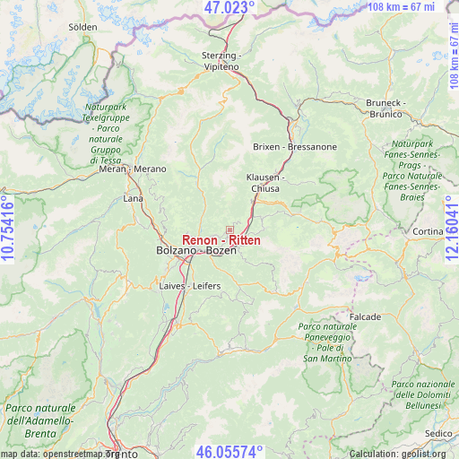
Renon - Ritten GPS coordinates[2]
46° 32' 29.472" North, 11° 27' 26.208" East
| Map corner | latitude | longitude |
|---|---|---|
| Upper-left | 47.023°, | 10.75416° |
| Center: | 46.54152°, | 11.45728° |
| Lower-right: | 46.05574°, | 12.16041° |
| Map W x H: | 107.5×107.5 km | = 66.8×66.8mi |
| max Lat: | 47.04031° ⇑1.4% North |
| Renon - Ritten: | 46.54152° |
| min Lat: | ⇓98.6% South 35.50142° |
| min Long | Renon - Ritten | max Long |
| 6.69888° | 11.45728° | 18.48682° |
| W 48.9%⇐ | ⇒51.1% E |
Elevation
Elevation of Renon - Ritten is 1208 m = 3963 ft, and this is 901.3 m = 2957 ft above average elevation for this country.
| Max E: |
2085 m = 6841 ft | 1.3% |
| Renon - Ritten | 1208 m 3963 ft | |
| Avg. | 306.7 m = 1006 ft | |
Min E: |
-4 m = -13 ft | 98.7% |
See also: Italy elevation on elevation.city.
Geographical zone
Renon - Ritten is located in North temperate zone (between Tropic of Cancer and the Arctic Circle). Distance of this North polar circle is 2226.2 km =1383.3 mi to North.| Distance of | km | miles | from Renon - Ritten |
|---|---|---|---|
| North Pole | 4832.1 | 3002.5 | to North |
| Arctic Circle | 2226.2 | 1383.3 | to North |
| Tropic Cancer | 2569 | 1596.3 | to South |
| Equator | 5174.9 | 3215.5 | to South |


Nearby cities:
15 places around Renon - Ritten: (largest is in red/bold)
• Auna di Sotto
3.5 km =2.2 mi,  200°
200°
• Barbiano
8.5 km =5.3 mi,  35°
35°
• Barbiano - Barbian
8.4 km =5.2 mi, 35°
• Bolzano
10.6 km =6.6 mi,  237°
237°
• Cardano
7.3 km =4.5 mi,  222°
222°
• Castelrotto
8.4 km =5.2 mi,  70°
70°
• Collalbo
0.2 km =0.1 mi,  139°
139°
• Collepietra
6.3 km =3.9 mi,  181°
181°
• Cornedo All'Isarco
6.9 km =4.3 mi,  214°
214°
• Fiè Allo Sciliar
4.4 km =2.7 mi,  129°
129°
• Ponte Gardena
8.4 km =5.2 mi, 42°
• San Genesio Atesino
9.8 km =6.1 mi,  265°
265°
• Siusi
7.8 km =4.8 mi,  90°
90°
• Soprabolzano
4.3 km =2.7 mi,  251°
251°
• Tires
9.7 km =6 mi,  146°
146°
Sources, notices
• [Note1] Compared only with cities in Italy existing in our database
• [Src1] Map data: © OpenStreetMap contributors (CC-BY-SA)
• [Src2] Other city data from geonames.org with taken over terms of usage.
• [Src3] Geographical zone / Annual Mean Temperature by Robert A. Rohde @ Wikipedia
