Casalromano geodata
Casalromano (Lombardy) is a seat of a third-order administrative division; located in Italy in Europe/Rome (GMT+2) time zone. With population of 1,054 people, there are 6457 cities with bigger population in this country. Compared to other cities in Italy, 64.9% of cities are located further ↓South; 64.3% of cities are located further →East and 83.1% of cities have higher elevation than Casalromano. Note1


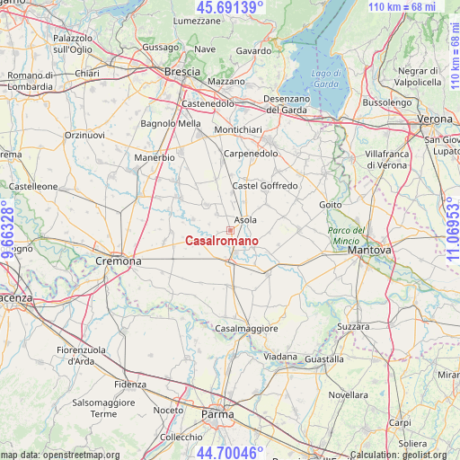
Casalromano GPS coordinates[2]
45° 11' 53.088" North, 10° 21' 59.04" East
| Map corner | latitude | longitude |
|---|---|---|
| Upper-left | 45.69139°, | 9.66328° |
| Center: | 45.19808°, | 10.3664° |
| Lower-right: | 44.70046°, | 11.06953° |
| Map W x H: | 110.2×110.2 km | = 68.5×68.5mi |
| max Lat: | 47.04031° ⇑35.1% North |
| Casalromano: | 45.19808° |
| min Lat: | ⇓64.9% South 35.50142° |
| min Long | Casalromano | max Long |
| 6.69888° | 10.3664° | 18.48682° |
| W 35.7%⇐ | ⇒64.3% E |
Elevation
Elevation of Casalromano is 37 m = 121 ft, and this is 269.7 m = 885 ft below average elevation for this country.
| Max E: |
2085 m = 6841 ft | 83.1% |
| Avg. | 306.7 m = 1006 ft | |
| Casalromano | 37 m = 121 ft | |
Min E: |
-4 m = -13 ft | 16.9% |
See also: Italy elevation on elevation.city.
Geographical zone
Casalromano is located in North temperate zone (between Tropic of Cancer and the Arctic Circle). Distance of this North polar circle is 2375.6 km =1476.1 mi to North.| Distance of | km | miles | from Casalromano |
|---|---|---|---|
| North Pole | 4981.5 | 3095.4 | to North |
| Arctic Circle | 2375.6 | 1476.1 | to North |
| Tropic Cancer | 2419.6 | 1503.5 | to South |
| Equator | 5025.6 | 3122.8 | to South |


Nearby cities:
15 places around Casalromano: (largest is in red/bold)
• Acquanegra sul Chiese
6.5 km =4 mi,  125°
125°
• Asola
4.3 km =2.7 mi,  55°
55°
• Canneto sull'Oglio
5.3 km =3.3 mi,  166°
166°
• Casalmoro
7.8 km =4.8 mi,  26°
26°
• Castelnuovo
8.8 km =5.5 mi,  51°
51°
• Drizzona
6.3 km =3.9 mi,  191°
191°
• Fiesse
5 km =3.1 mi,  318°
318°
• Gambara
8.4 km =5.2 mi, 317°
• Isola Dovarese
5.3 km =3.3 mi,  238°
238°
• Piadena
7.7 km =4.8 mi,  177°
177°
• Remedello
8.9 km =5.5 mi,  2°
2°
• Remedello di Sopra
9 km =5.6 mi, 2°
• Remedello di Sotto
7 km =4.3 mi,  8°
8°
• Torre de' Picenardi
8.7 km =5.4 mi,  225°
225°
• Volongo
5.2 km =3.2 mi,  286°
286°
Sources, notices
• [Note1] Compared only with cities in Italy existing in our database
• [Src1] Map data: © OpenStreetMap contributors (CC-BY-SA)
• [Src2] Other city data from geonames.org with taken over terms of usage.
• [Src3] Geographical zone / Annual Mean Temperature by Robert A. Rohde @ Wikipedia
