Castello geodata
Castello (Lombardy) is a seat of a third-order administrative division; located in Italy in Europe/Rome (GMT+2) time zone. With population of 1,215 people, there are 5912 cities with bigger population in this country. Compared to other cities in Italy, 75.9% of cities are located further ↓South; 62.8% of cities are located further →East and 50.9% of cities have higher elevation than Castello. Note1
Administrative division(s):
- Level 1: Lombardy
- Level 2: Provincia di Brescia
- Level 3: Puegnago sul Garda


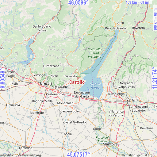
Castello GPS coordinates[2]
45° 34' 10.344" North, 10° 30' 30.996" East
| Map corner | latitude | longitude |
|---|---|---|
| Upper-left | 46.0596°, | 9.80549° |
| Center: | 45.56954°, | 10.50861° |
| Lower-right: | 45.07517°, | 11.21174° |
| Map W x H: | 109.5×109.5 km | = 68×68mi |
| max Lat: | 47.04031° ⇑24.1% North |
| Castello: | 45.56954° |
| min Lat: | ⇓75.9% South 35.50142° |
| min Long | Castello | max Long |
| 6.69888° | 10.50861° | 18.48682° |
| W 37.2%⇐ | ⇒62.8% E |
Elevation
Elevation of Castello is 229 m = 751 ft, and this is 77.7 m = 255 ft below average elevation for this country.
| Max E: |
2085 m = 6841 ft | 50.9% |
| Avg. | 306.7 m = 1006 ft | |
| Castello | 229 m = 751 ft | |
Min E: |
-4 m = -13 ft | 49.1% |
See also: Italy elevation on elevation.city.
Geographical zone
Castello is located in North temperate zone (between Tropic of Cancer and the Arctic Circle). Distance of this North polar circle is 2334.3 km =1450.5 mi to North.| Distance of | km | miles | from Castello |
|---|---|---|---|
| North Pole | 4940.2 | 3069.7 | to North |
| Arctic Circle | 2334.3 | 1450.5 | to North |
| Tropic Cancer | 2460.9 | 1529.1 | to South |
| Equator | 5066.9 | 3148.4 | to South |


Nearby cities:
15 places around Castello: (largest is in red/bold)
• Chiesa
3.7 km =2.3 mi,  259°
259°
• Cunettone-Villa
2.2 km =1.4 mi,  18°
18°
• Manerba del Garda
4 km =2.5 mi,  122°
122°
• Muscoline
3.7 km =2.3 mi, 257°
• Pieve Vecchia
3 km =1.9 mi,  96°
96°
• Polpenazze del Garda
2.1 km =1.3 mi,  188°
188°
• Puegnago sul Garda
0.3 km =0.2 mi,  163°
163°
• Raffa
1.6 km =1 mi,  86°
86°
• Roè Volciano
5 km =3.1 mi,  341°
341°
• Salò
4.3 km =2.7 mi,  12°
12°
• San Biagio
4.1 km =2.5 mi,  300°
300°
• San Felice del Benaco
3.8 km =2.4 mi,  67°
67°
• San Giacomo
3.7 km =2.3 mi,  317°
317°
• Soiano
4.7 km =2.9 mi,  176°
176°
• Solarolo
4.2 km =2.6 mi, 120°
Sources, notices
• [Note1] Compared only with cities in Italy existing in our database
• [Src1] Map data: © OpenStreetMap contributors (CC-BY-SA)
• [Src2] Other city data from geonames.org with taken over terms of usage.
• [Src3] Geographical zone / Annual Mean Temperature by Robert A. Rohde @ Wikipedia
