Cunettone-Villa geodata
Cunettone-Villa (Lombardy) is a populated place; located in Italy in Europe/Rome (GMT+2) time zone. With population of 1,412 people, there are 5332 cities with bigger population in this country. Compared to other cities in Italy, 76.5% of cities are located further ↓South; 62.7% of cities are located further →East and 61% of cities have higher elevation than Cunettone-Villa. Note1


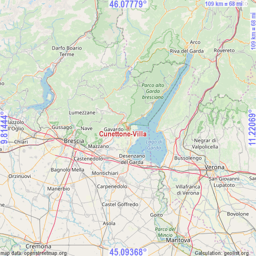
Cunettone-Villa GPS coordinates[2]
45° 35' 16.404" North, 10° 31' 3.216" East
| Map corner | latitude | longitude |
|---|---|---|
| Upper-left | 46.07779°, | 9.81444° |
| Center: | 45.58789°, | 10.51756° |
| Lower-right: | 45.09368°, | 11.22069° |
| Map W x H: | 109.4×109.4 km | = 68×68mi |
| max Lat: | 47.04031° ⇑23.5% North |
| Cunettone-Villa: | 45.58789° |
| min Lat: | ⇓76.5% South 35.50142° |
| min Long | Cunettone-Villa | max Long |
| 6.69888° | 10.51756° | 18.48682° |
| W 37.3%⇐ | ⇒62.7% E |
Elevation
Elevation of Cunettone-Villa is 155 m = 509 ft, and this is 151.7 m = 498 ft below average elevation for this country.
| Max E: |
2085 m = 6841 ft | 61% |
| Avg. | 306.7 m = 1006 ft | |
| Cunettone-Villa | 155 m = 509 ft | |
Min E: |
-4 m = -13 ft | 39% |
See also: Italy elevation on elevation.city.
Geographical zone
Cunettone-Villa is located in North temperate zone (between Tropic of Cancer and the Arctic Circle). Distance of this North polar circle is 2332.3 km =1449.2 mi to North.| Distance of | km | miles | from Cunettone-Villa |
|---|---|---|---|
| North Pole | 4938.2 | 3068.5 | to North |
| Arctic Circle | 2332.3 | 1449.2 | to North |
| Tropic Cancer | 2463 | 1530.4 | to South |
| Equator | 5068.9 | 3149.7 | to South |


Nearby cities:
15 places around Cunettone-Villa: (largest is in red/bold)
• Castello
2.2 km =1.4 mi,  198°
198°
• Chiesa
5.1 km =3.2 mi,  238°
238°
• Manerba del Garda
5 km =3.1 mi,  147°
147°
• Muscoline
5.2 km =3.2 mi, 236°
• Pieve Vecchia
3.3 km =2.1 mi,  136°
136°
• Polpenazze del Garda
4.2 km =2.6 mi,  193°
193°
• Puegnago sul Garda
2.4 km =1.5 mi, 194°
• Raffa
2.2 km =1.4 mi, 154°
• Roè
4.4 km =2.7 mi,  341°
341°
• Roè Volciano
3.5 km =2.2 mi,  319°
319°
• Salò
2.1 km =1.3 mi,  6°
6°
• San Biagio
4.2 km =2.6 mi,  270°
270°
• San Felice del Benaco
2.9 km =1.8 mi,  101°
101°
• San Giacomo
3.2 km =2 mi,  281°
281°
• Solarolo
5.1 km =3.2 mi, 145°
Sources, notices
• [Note1] Compared only with cities in Italy existing in our database
• [Src1] Map data: © OpenStreetMap contributors (CC-BY-SA)
• [Src2] Other city data from geonames.org with taken over terms of usage.
• [Src3] Geographical zone / Annual Mean Temperature by Robert A. Rohde @ Wikipedia
