Soiano geodata
Soiano (Lombardy) is a seat of a third-order administrative division; located in Italy in Europe/Rome (GMT+2) time zone. With population of 1,605 people, there are 4897 cities with bigger population in this country. Compared to other cities in Italy, 74.6% of cities are located further ↓South; 62.7% of cities are located further →East and 55.8% of cities have higher elevation than Soiano. Note1
Administrative division(s):
- Level 1: Lombardy
- Level 2: Provincia di Brescia
- Level 3: Soiano del Lago


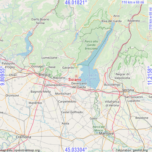
Soiano GPS coordinates[2]
45° 31' 40.008" North, 10° 30' 45.612" East
| Map corner | latitude | longitude |
|---|---|---|
| Upper-left | 46.01821°, | 9.80955° |
| Center: | 45.52778°, | 10.51267° |
| Lower-right: | 45.03304°, | 11.2158° |
| Map W x H: | 109.5×109.5 km | = 68×68mi |
| max Lat: | 47.04031° ⇑25.4% North |
| Soiano: | 45.52778° |
| min Lat: | ⇓74.6% South 35.50142° |
| min Long | Soiano | max Long |
| 6.69888° | 10.51267° | 18.48682° |
| W 37.3%⇐ | ⇒62.7% E |
Elevation
Elevation of Soiano is 197 m = 646 ft, and this is 109.7 m = 360 ft below average elevation for this country.
| Max E: |
2085 m = 6841 ft | 55.8% |
| Avg. | 306.7 m = 1006 ft | |
| Soiano | 197 m = 646 ft | |
Min E: |
-4 m = -13 ft | 44.2% |
See also: Italy elevation on elevation.city.
Geographical zone
Soiano is located in North temperate zone (between Tropic of Cancer and the Arctic Circle). Distance of this North polar circle is 2339 km =1453.4 mi to North.| Distance of | km | miles | from Soiano |
|---|---|---|---|
| North Pole | 4944.8 | 3072.6 | to North |
| Arctic Circle | 2339 | 1453.4 | to North |
| Tropic Cancer | 2456.3 | 1526.3 | to South |
| Equator | 5062.2 | 3145.5 | to South |


Nearby cities:
15 places around Soiano: (largest is in red/bold)
• Barcuzzi
4.8 km =3 mi,  196°
196°
• Calvagese della Riviera
5.3 km =3.3 mi,  283°
283°
• Carzago Riviera
4.1 km =2.5 mi,  264°
264°
• Castello
4.7 km =2.9 mi,  356°
356°
• Chiesa
5.6 km =3.5 mi,  315°
315°
• Manerba del Garda
3.9 km =2.4 mi,  51°
51°
• Moniga del Garda
1.9 km =1.2 mi,  93°
93°
• Muscoline
5.5 km =3.4 mi,  314°
314°
• Padenghe sul Garda
2.3 km =1.4 mi,  168°
168°
• Pieve Vecchia
5 km =3.1 mi,  31°
31°
• Polpenazze del Garda
2.7 km =1.7 mi,  346°
346°
• Puegnago sul Garda
4.3 km =2.7 mi, 357°
• Raffa
4.9 km =3 mi,  15°
15°
• Sedena
5.5 km =3.4 mi,  214°
214°
• Solarolo
4.1 km =2.5 mi, 52°
Sources, notices
• [Note1] Compared only with cities in Italy existing in our database
• [Src1] Map data: © OpenStreetMap contributors (CC-BY-SA)
• [Src2] Other city data from geonames.org with taken over terms of usage.
• [Src3] Geographical zone / Annual Mean Temperature by Robert A. Rohde @ Wikipedia
