Solarolo geodata
Solarolo (Lombardy) is a seat of a third-order administrative division; located in Italy in Europe/Rome (GMT+2) time zone. With population of 3,614 people, there are 2612 cities with bigger population in this country. Compared to other cities in Italy, 75.3% of cities are located further ↓South; 62.2% of cities are located further →East and 67.1% of cities have higher elevation than Solarolo. Note1
Administrative division(s):
- Level 1: Lombardy
- Level 2: Provincia di Brescia
- Level 3: Manerba del Garda


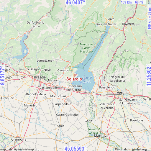
Solarolo GPS coordinates[2]
45° 33' 1.692" North, 10° 33' 17.604" East
| Map corner | latitude | longitude |
|---|---|---|
| Upper-left | 46.0407°, | 9.85177° |
| Center: | 45.55047°, | 10.55489° |
| Lower-right: | 45.05593°, | 11.25802° |
| Map W x H: | 109.5×109.5 km | = 68×68mi |
| max Lat: | 47.04031° ⇑24.7% North |
| Solarolo: | 45.55047° |
| min Lat: | ⇓75.3% South 35.50142° |
| min Long | Solarolo | max Long |
| 6.69888° | 10.55489° | 18.48682° |
| W 37.8%⇐ | ⇒62.2% E |
Elevation
Elevation of Solarolo is 115 m = 377 ft, and this is 191.7 m = 629 ft below average elevation for this country.
| Max E: |
2085 m = 6841 ft | 67.1% |
| Avg. | 306.7 m = 1006 ft | |
| Solarolo | 115 m = 377 ft | |
Min E: |
-4 m = -13 ft | 32.9% |
See also: Italy elevation on elevation.city.
Geographical zone
Solarolo is located in North temperate zone (between Tropic of Cancer and the Arctic Circle). Distance of this North polar circle is 2336.4 km =1451.8 mi to North.| Distance of | km | miles | from Solarolo |
|---|---|---|---|
| North Pole | 4942.3 | 3071 | to North |
| Arctic Circle | 2336.4 | 1451.8 | to North |
| Tropic Cancer | 2458.8 | 1527.8 | to South |
| Equator | 5064.7 | 3147.1 | to South |


Nearby cities:
15 places around Solarolo: (largest is in red/bold)
• Castello
4.2 km =2.6 mi,  300°
300°
• Chiesa
7.4 km =4.6 mi,  281°
281°
• Cunettone-Villa
5.1 km =3.2 mi,  325°
325°
• Manerba del Garda
0.2 km =0.1 mi,  252°
252°
• Moniga del Garda
3 km =1.9 mi,  207°
207°
• Muscoline
7.4 km =4.6 mi, 280°
• Padenghe sul Garda
5.5 km =3.4 mi, 210°
• Pieve Vecchia
1.9 km =1.2 mi,  339°
339°
• Polpenazze del Garda
3.9 km =2.4 mi,  271°
271°
• Puegnago sul Garda
4 km =2.5 mi, 297°
• Raffa
3 km =1.9 mi,  318°
318°
• Salò
6.8 km =4.2 mi, 336°
• San Felice del Benaco
3.6 km =2.2 mi,  358°
358°
• Sirmione
7.1 km =4.4 mi,  146°
146°
• Soiano
4.1 km =2.5 mi,  232°
232°
Sources, notices
• [Note1] Compared only with cities in Italy existing in our database
• [Src1] Map data: © OpenStreetMap contributors (CC-BY-SA)
• [Src2] Other city data from geonames.org with taken over terms of usage.
• [Src3] Geographical zone / Annual Mean Temperature by Robert A. Rohde @ Wikipedia
