Santeramo in Colle geodata
Santeramo in Colle (Apulia) is a seat of a third-order administrative division; located in Italy in Europe/Rome (GMT+2) time zone. With population of 24,922 people, there are 329 cities with bigger population in this country. Compared to other cities in Italy, 81.5% of cities are located further ↑North; 97.4% of cities are located further ←West and 78.3% of cities have lower elevation than Santeramo in Colle. Note1


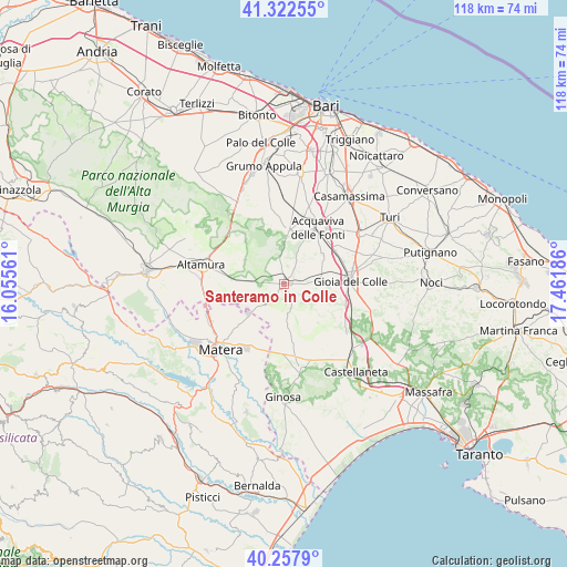
Santeramo in Colle GPS coordinates[2]
40° 47' 32.496" North, 16° 45' 31.428" East
| Map corner | latitude | longitude |
|---|---|---|
| Upper-left | 41.32255°, | 16.05561° |
| Center: | 40.79236°, | 16.75873° |
| Lower-right: | 40.2579°, | 17.46186° |
| Map W x H: | 118.4×118.4 km | = 73.6×73.6mi |
| max Lat: | 47.04031° ⇑81.5% North |
| Santeramo in Colle: | 40.79236° |
| min Lat: | ⇓18.5% South 35.50142° |
| min Long | Santeramo in Co | max Long |
| 6.69888° | 16.75873° | 18.48682° |
| W 97.4%⇐ | ⇒2.6% E |
Elevation
Elevation of Santeramo in Colle is 496 m = 1627 ft, and this is 189.3 m = 621 ft above average elevation for this country.
| Max E: |
2085 m = 6841 ft | 21.7% |
| Santeramo in Colle | 496 m 1627 ft | |
| Avg. | 306.7 m = 1006 ft | |
Min E: |
-4 m = -13 ft | 78.3% |
See also: Italy elevation on elevation.city.
Geographical zone
Santeramo in Colle is located in North temperate zone (between Tropic of Cancer and the Arctic Circle). Distance of this Northern Tropic circle is 1929.8 km =1199.1 mi to South.| Distance of | km | miles | from Santeramo in Colle |
|---|---|---|---|
| North Pole | 5471.4 | 3399.8 | to North |
| Arctic Circle | 2865.5 | 1780.5 | to North |
| Tropic Cancer | 1929.8 | 1199.1 | to South |
| Equator | 4535.7 | 2818.4 | to South |


Nearby cities:
15 places around Santeramo in Colle: (largest is in red/bold)
• Acquaviva delle Fonti
13.6 km =8.5 mi,  31°
31°
• Altamura
18 km =11.2 mi,  282°
282°
• Borgo Fra' Diavolo
10.8 km =6.7 mi,  344°
344°
• Casamassima
22.8 km =14.2 mi,  36°
36°
• Cassano delle Murge
11 km =6.8 mi,  2°
2°
• Castellaneta
23.4 km =14.5 mi,  141°
141°
• Ginosa
24 km =14.9 mi,  180°
180°
• Gioia del Colle
13.8 km =8.6 mi,  86°
86°
• La Martella
23.7 km =14.7 mi,  232°
232°
• Laterza
18.5 km =11.5 mi,  169°
169°
• Matera
19.1 km =11.9 mi,  222°
222°
• Parco Principi
24.4 km =15.2 mi, 30°
• Sammichele di Bari
19.2 km =11.9 mi,  56°
56°
• Sannicandro di Bari
23.4 km =14.5 mi,  7°
7°
• Toritto
23.8 km =14.8 mi, 343°
Sources, notices
• [Note1] Compared only with cities in Italy existing in our database
• [Src1] Map data: © OpenStreetMap contributors (CC-BY-SA)
• [Src2] Other city data from geonames.org with taken over terms of usage.
• [Src3] Geographical zone / Annual Mean Temperature by Robert A. Rohde @ Wikipedia
